McKownville
Improvement Association
- property ownership and deeds for Great lots
18, 19 & 20 west of Fuller Road (1818 to ~1926)
| Deed book, pages | property | Grantors | grantee | date | date recorded |
| 62; 33-5 |
gt lots 18 & 19 (114.8ac) |
City of Albany (Mayor, etc) | Abel French, James McKown |
1818-03-23 |
1838-06-14 |
| 62; 35-6 |
gt lots 18 & 19 (114.8ac) | Abel French, James & Susan McKown | James M French |
1836-03-15 |
1838-06-14 |
| 72; 441-2 |
½ac square NE cnr lot 18 |
James M & Sarah A French | Bethel Jacob Jewish Congregation |
1841-08-10 |
1841-08-11 |
| 89; 312-3 |
gt lots 18 & 19 (114.8ac) | James M & Sarah A French | Abel French | 1846-07-21 |
1846-07-22 |
| 105; 449-50 |
gt lots 18 & 19 (114.8ac) xc cem, road |
Abel French | Stephen Averill |
1849-04-01 |
1850-03-26 |
| 126; 218-9 |
gt lots 18, 19 xc cem, road | Stephen Averill | Alanson Gates |
1851-09-21 |
1854-03-13 |
| 137; 300-1 |
gt lots 18, 19 xc cem, road | Alanson A & Jane Gates | Samuel S Tallant | 1856-02-29 |
1856-02-29 |
| 147; 58-60 |
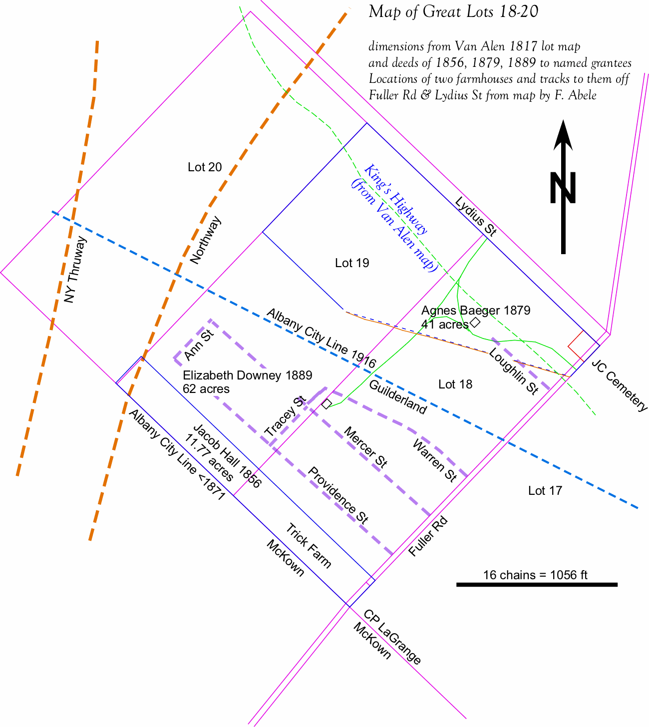
11.77ac S ends 18 & 19 | Samuel S & Matilda Tallant |
Jacob Hall |
1856-10-10 |
1857-09-10 |
| 188; 202-3 |
11.77ac S ends 18, 19 (&20) | Jacob & Martha I Hall | Samuel S Tallant | 1864-05-30 |
1864-05-30 |
| 199; 420-2 |
11.77ac S ends 18, 19 (&20) gt lots 18, 19 xc cem, road |
Samuel S & Matilda Tallant | John Rea & James Woodward | 1865-11-09 |
1866-01-11 |
| 199; 422-5 |
11.77ac S ends 18, 19 (&20) | John & Nancy Rea & James & Amelia Woodward |
Samuel S Tallant | 1866-01-11 |
1866-01-11 |
| 204; 544-6 |
gt lots 18, 19, 20 xc cem, road |
Samuel S & Matilda Tallant | James L Baker |
1867-03-04 |
1867-03-06 |
| 227; 268-70 |
gt lots 18, 19, 20 xc cem, road | James L & Anna E Baker | George Canaday | 1869-11-02 |
1869-11-05 |
| 232; 216-8 |
11.77ac S ends 18, 19 (&20) | George & Catherine Canaday | James D White |
1870-02-15 |
1870-05-23 |
| 232; 223-5 |
gt lots 18 & 19 (102.8ac) xc burying gd NE cnr 18 & 11.77ac S ends 18 & 19 |
George & Catherine Canaday | Benjamin N Finch |
1870-04-30 |
1870-05-23 |
| 233; 385-7 |
11.77ac S ends 18, 19 (&20) | James D & Mary J White | Thomas Wigfall |
1870-08-03 |
1870-08-12 |
| 242; 50-2 |
11.77ac S ends 18, 19 (&20) | Thomas Wigfall | Jeremiah P Russell |
1871-03-22 |
1871-05-20 |
| 243; 471-3 |
11.77ac S ends 18, 19 (&20) | Jeremiah P & Christina Russell | Robert L Fryer |
1871-08-06 |
1871-08-26 |
| 244; 390-2 |
gt lots 18 & 19 xc cem, road & 11.77ac S ends |
Benjamin N & Sarah M Finch | Nathaniel Griffith |
1870-11-14 |
1871-10-12 |
| 245; 364-7 |
gt lots 18 & 19 xc cem, road & 11.77ac S ends |
Nathaniel Griffith | Lewis H & Eveline Griffith |
1871-09-01 |
1871-11-18 |
| 247; 371-2 |
11.77ac S ends 18, 19 (&20) | Robert L Fryer | Stephen Rockefeller |
1871-10-03 |
1872-01-25 |
| 252; 35-7 |
11.77ac S ends 18, 19 (&20) | Stephen & Annis B Rockefeller | James O Woodruff |
1872-02-01 |
1872-03-08 |
| 282; 41-4 |
11.77ac S ends 18, 19 (&20) | James O & Ermina J Woodruff | Dewitt H Phillips | 1872-02-23 |
1875-05-11 |
| 267; 434-6 |
gt lots 18 & 19 xc cem, road & 11.77ac S ends |
Alva H Tremain (Referee) |
Benjamin N Finch |
1873-11-15 |
1873-11-21 |
| 274; 277-80 |
gt lots 18 & 19 xc cem, road & 11.77ac S ends |
Benjamin N & Sarah Finch | William H Bailey, Thomas Helme | 1874-06-11 |
1874-09-22 |
| 279; 473-5 |
11.77ac S ends 18, 19 (&20) | Dewitt H & Rachael Phillips |
Asahel Dewal |
1875-05-10 |
1875-05-27 |
| 308; 334-6 |
gt lots 18 & 19 xc cem, road & 11.77ac S ends |
William H & Ann E Bailey | Charles Baiger | 1878-03-18 |
1878-03-22 |
| 309; 223-4 |
gt lots 18 & 19 xc cem, road & 11.77ac S ends |
Charles Baiger |
Theresa Lohre (Baiger) | 1878-03-29 | 1878-03-30 |
| 322; 314-6 |
11.77ac S ends 18, 19 (&20) | Scott B M Goodwin (Referee) |
Martha I Hall | 1879-05-31 |
1880-03-17 |
| 319; 60-1 |
41 acres N part lots 18, 19 |
Theresa Lohre (Baeger) |
Agnes Baeger |
1879-06-19 |
1879-06-21 |
| 334; 506- |
41 acres N part lots 18, 19 | D Louis Dreyer & wf |
Anna Heim |
1881-08-03 |
1881-09-09 |
| addn to cemetery NE cnr lot 18 | Congregation Sons of Abraham |
1883-10-08 |
|||
| 369; 258-9 |
62 acres remainder lots 18, 19 |
Theresa Lohre (Baeger) | James A Wiltse | 1885-10-31 |
1885-11-09 |
| 372; 315-7 |
11.77ac S ends 18, 19 (&20) | Martha I Hall | D Oscar Denison | 1886-02-13 |
1886-03-23 |
| 378; 56-8 |
11.77ac S ends 18, 19 (&20) | D Oscar & Maria E Denison |
James A Wiltse | 1886-10-04 |
1886-10-04 |
| 406; 447-9 |
62 acres remainder lots 18, 19 |
James A & Margaret B Wiltse | Elizabeth Downey (>John J D) |
1889-05-01 |
1889-06-14 |
| 456; 378-81 |
11.77ac S ends 18, 19 (&20) | Margaret R & David Wiltse |
John L Hein |
1891-04-23 |
1895-11-16 |
| 456; 381-3 |
11.77ac S ends 18, 19 (&20) | John L & Georgiana Hein | Charles Friebel | 1895-11-16 | 1895-11-16 |
| 516; 120- | 35ac of lot 20 | Charles & Natalie Friebel | Hugh Friebel | 1900-09-05 | |
| 603; 450-2 |
22.4ac of lot 20; 11.77ac (S18,19) | Natalie Friebel |
Fred & Selma Trick |
1913-04-10 |
1913-05-09 |
| 651; 122- | 22.4ac of lot 20; 11.77ac (S18,19) | Fred & Selma Trick | Mary L Cox | 1916-07-14 | |
| 763; 236- |
41 acres N part lots 18, 19 |
Carl Ziemann
|
Louis Ziemann |
1919-07-19 |
1925-08-11
|
| 774; 54-5 |
62 acres remainder lots 18, 19 |
John J Downey |
William W Farley |
1926-04-07 | 1926-04-08 |
| 925; 181-3 |
41 acres N part lots 18, 19 | Henry Walter (administrator L Ziemann) | George H C Farley | 1940-08-29 | 1940-09-03 |
| 951; 207-9 |
41 acres N part lots 18, 19 | George H C & Mary E H Farley |
William W Farley | 1942-01-21 |
1942-12-10 |
| 945; 495-6 |
addn to cemetery NE cnr lot 18 (1ac) |
William W Farley | Congregation Beth El Jacob |
1943-04-14 |
1943-04-14 |
| 1019; 209-12 |
22.4ac of lot 20; 11.77ac (S18,19) | Mary L Cox | William E & Mary L Trick | 1946-06-18 | 1946-06-20 |
| 1048; 18-21 |
41 acres N part lots 18, 19 | William W Farley |
William W & George H C Farley
|
1946-12-24 |
1946-12-30 |
| 1401; 386-8 |
5.82ac (S pt lot 19); 1.13ac (pt lot 20) |
William E & Mary L Trick | Niagara-Mohawk Power Corp | 1954-05-07 |
1954-05-18 |
| 1716; 289-90 |
5.82ac (S pt lot 18) | William E & Mary L Trick | Irving Kirsch & Sidney Albert | 1962-04-26 | 1962-04-26 |
| 1871; 535-8 |
2.15ac (part S pt lot 19) |
Niagara-Mohawk Power Corp | Stuyvesant Plaza Inc |
1965-09-27 |
1966-06-21 |
| Deed book, pages | property | Grantors | grantee | date | date recorded |
| 25; 2-4 |
great lots 14, 15, (113.9ac), & lots 4 (43.9ac), 20, 21 (114.8ac) |
City of Albany (Mayor, etc) | John Taylor | 1818-03-23 | 1819-01-12 |
| 25; 17 |
great lots 20, 21 (114.8ac) | John Taylor | Thomas Gould |
1818-12-31 |
1819-01-16 |
| 188; 202-3 |
11.77ac S ends 18, 19 (&20)# | Jacob & Martha I Hall | Samuel S Tallant | 1864-05-30 | 1864-05-30 |