The federal-style brick house owned by William Amsdell, located
at 1188 Western Avenue [built 1830?]
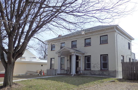
William Amsdell was a brewer, who purchased in 1834
the 19 acre property in which this house was built, and from 1841
established the Guilderland Brewery nearby, running that
business probably until shortly before he died in 1864. From 1854
two of his sons, George and Theodore, set up a brewery among the
many that were located in Albany in the mid-late 19th century, and
which grew large and prospered under their direction.
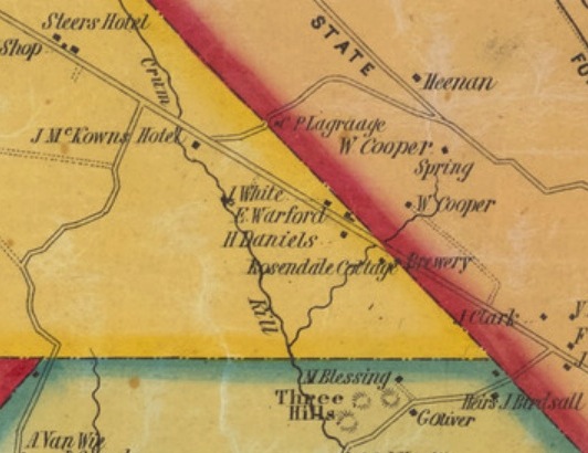
Excerpt from the Map of the vicinity of Albany and Troy 1851 by
John Sidney,
which shows the brewery (of William Amsdell) on the Great
Western Turnpike
at the Albany City line, and the house to the west of it
labelled Rosendale Cottage,
(presumably the name given it by William Amsdell, who emigrated
from England,
and where it was customary to name houses in this manner).
It seems likely that this brewery supplied beer to the nearby McKown's Hotel and tavern, and the
other hotels in Guilderland along the Great Western Turnpike,
avoiding some of the tolls which Albany breweries would have had to
pay.
This house was rented by the time of the 1865 NY census, to John
Weaver, but Amsdell Bros. is marked in this place on the map of Guilderland in the Beers portfolio of 1866,
and the Amsdell sons appear to have continued to run it as a brewery
for some time after this date (see this map
from 1876). The Amsdell family eventually sold this property
in 1886.
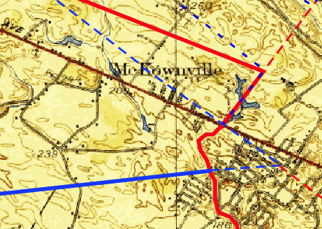
In the 19th century McKownville extended farther east, in a
triangular area south of Western Avenue and east of the Krumkill
stream branch which passes under the road by the University
entrance. The map below
shows the change, which occurred when the City of Albany annexed the
area, along with a much larger piece of the Town of Bethlehem, in
1916. Up to that time, this house was in the Town of Guilderland,
and in McKownville.
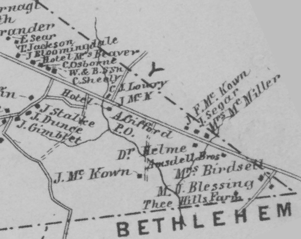
Left - Part of the Beers 1866 map of
Guilderland, showing the area of McKownville,
and the Amsdell Bros building marked on the south side of the
Western Turnpike,
just east of the Krumkill stream east branch, and within the Town of
Guilderland.
Right - 1927 USGS topographic map, annotated: solid red -
present Albany city line, since 1916; dashed red - Albany city line
from 1871-1912;
longer dashed blue - Guilderland boundaries prior to 1871; shorter
dashed blue - Guilderland-Albany boundary 1913-1916.
The triangular piece south of Western Avenue originally in
Guilderland was annexed by the City of Albany in 1916. solid blue -
Guilderland-Bethlehem town line.
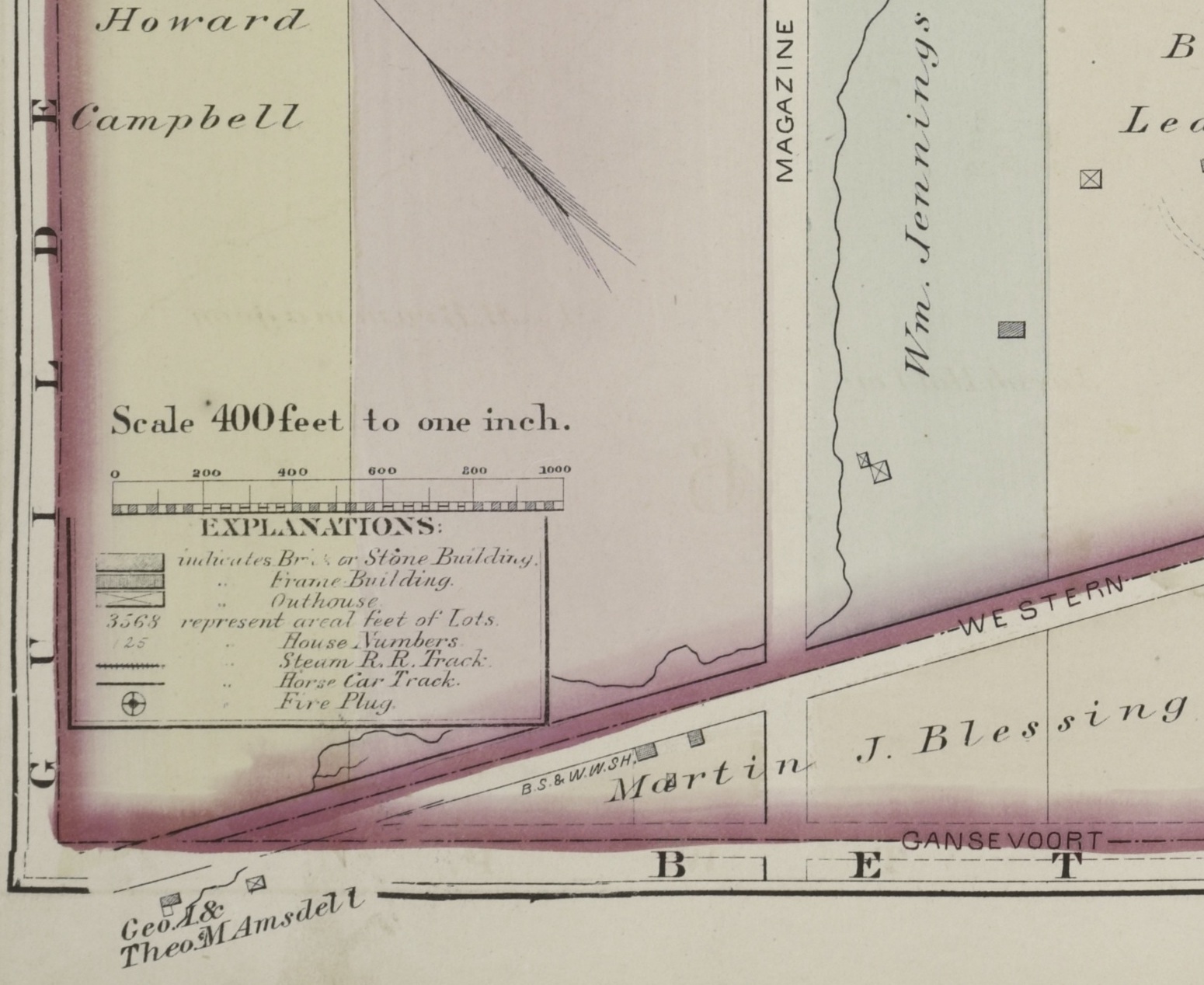
Below - part of GH Hopkins 1876 map
of Albany. Near the lower left corner a brick house and an
"outhouse" (probably a barn) east of it are shown belonging to
George and Theodore Amsdell. The brick house is in the right
position to be 1188 Western Avenue.
The occupants of this house after 1865 are not clearly identifiable
until 1892, when John Geisel "gardener" and owner of the property is
listed in the NY census. In the 1900 federal census Anton Keller,
"gardener", is the owner, having purchased it earlier that year. He
sold it in 1908 to Bernard V Sheehan, listed in the 1910 census as a
wholesale meat merchant, and in a later census a salesman and buyer,
so it then ceased to be a farmhouse. The Sheehan heirs sold it in
1952, and from 1953 the occupants listed in the yearly city
directories were individuals renting three apartments, which
situation continues to the present.
Listing (with links) of deeds to the
property containing the house now at 1188 Western Avenue
William Amsdell bought this property in 1834, while he was working
for a brewery in Albany. It is not certain whether he built the
house which still stands here, or whether it is older. The deed
of 1834 includes a consideration of $1800, and mentions a
"messauge" (usually this meant a house), and also specifies an
existing $500
mortgage taken out by the seller in 1830, and passed to
Amsdell in the 1834 conveyance. This might support the idea that the
house was built in 1830. The federal architectural style is more
consistent with a construction date older than 1834, although it
would have already been seen in 1830 as old-fashioned by the more
prosperous citizens of Albany.
return to McKownville
older buildings photo index page
return to McKownville Improvement
Association index page