McKownville
Improvement Association
- McKownville - name, attempts to rename, or
form a village; annexations
Name of the hamlet
The area now known as McKownville has been part of the Town of
Guilderland since 1803, when the town was created.
Early in the 19th century it was according to one
source known informally as West Brighton, but by 1862 when the
McKownville
Post Office was first opened, the name McKownville was clearly
an established usage. This was from the McKown
family, the earliest to build a dwelling in this area, and in
particular William McKown (1763-1843), the proprietor of McKown's Hotel and
tavern on the Great
Western Turnpike.
The Altamont Enterprise newspaper before 1893 used "McKownsville",
as did the 1897 compendium Landmarks of Albany County, which
has a brief
description of the settlement. A document created for the
restablishment of the McKownville Post Office in 1871 contains the name
McKownsville handwritten, but with the "s" firmly crossed out.
The McKownville Post Office was discontinued in 1905.

The earliest map containing the name is the USGS Albany quadrangle
of 1893, which reads "McKownville", and which has remained the same
on all maps since that time.
The Bein atlas of 1895 shows
McKownville on the map of Albany, Rensselaer, and Columbia
Counties.
1917 - Village of Witbeck petition
A proposal to change the name of the hamlet was made early in 1917,
as part of an attempt to incorporate it as a formally (and legally)
defined village. A petition to establish the "Village of Witbeck"
was circulated for signature and submitted to the Town of
Guilderland, and was approved by the Town Supervisor. However an
appeal to the Albany County Court by residents opposed to the
proposal caused reversal of this decision, the court upholding the
claim that the petition was faulty. No further activity on this
proposal appears to have occurred after this rejection. An amusing
contemporary report in the Altamont Enterprise covers this
only documented attempt to change the name of the place. There is a
recently published historical article in the
Enterprise about the Witbecks, including this event.
1918 - McKownville Fire District petition
Early in 1918 a successful petition by residents
to the Albany County Board of Supervisors resulted in the
establishment of the McKownville Fire District. The boundaries of
the District initially extended along Western Avenue/Turnpike to the
present Johnston and Rapp Road intersection. After the establishment
of the Westmere Fire District in 1937, the McKownville Fire District
western boundary was more formally defined approximately at
its present position near Schoolhouse Road.
1926 - discussion of village incorporation
Minutes of the McKownville Improvement Association board
meeting in September 1926 record the intention to hold a
special open meeting in October 1926 to discuss village
incorporation. The files also include a map drawn in
1927 for the voting district for such an incorporation.
However, no report or formal notice of such a proposal can be found
in the pages of the Altamont Enterprise of that time, so it is
presumed that the matter was not pursued after the meeting.
1965 - discussion of village incorporation
In 1964 the Guilderland Planning Board recommended a
major lot size reduction for residential properties with the
intention of permitting development of high-rise apartments in areas
formerly zoned for one-family detached houses. The McKownville
Improvement Association went so far as to respond to this threat to
the neighborhood and its limited water supply by setting up a formal
committee and calling
a public meeting in January 1965 to discuss incorporation as a
village, as a means to avoid this undesired imposition. This
zoning change recommendation was in the end not adopted, and no
further action toward village incorporation is recorded.
1980 - discussion and in-depth study of village incorporation in
the attempt to prevent the building of Crossgates
Early in 1980, the McKownville Improvement Association began an
extensive study of village incorporation, and promoted public
discussion of the possibility, starting with the 18th
March 1980 meeting. The primary motivation was the possibility
of gaining local control over zoning of some part of the area
required by the developers of Crossgates, and of the McKownville
Reservoir watershed and Water District, and thereby preventing the
construction. A meeting was held 18 June 1980 where Don
Reeb presented to residents his arguments and the facts
derived from his research into village incorporation. Reports after
this meeting show that opinion
was divided, and a significant number of residents opposed
the idea, even though it was shown that no net tax increase would
occur. A subcommittee of the Association continued to work,
gathering more information from other New York State villages, and
on an opinion survey of residents, into the fall of 1980, but the
effort was then abandoned.
Annexation events and attempts affecting McKownville and
adjoining areas
1871 - transfer of much of the area of the Liberty of Albany to
the Town of Guilderland

part of map of Albany County (Beers atlas 1866) showing the
boundaries of the City of Albany before the 1871 truncation.
The long strip extending to the Schenectady County Line was
known as the Liberty of Albany.
(click on any of the bordered maps to see an enlarged image)

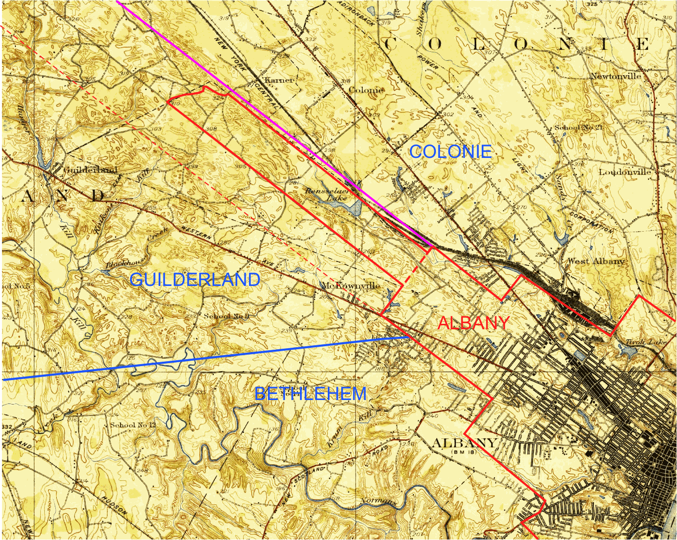
USGS 1927 Albany quad map annotated showing:
City of Albany boundary from 1871-1912 (red);
Guilderland-Watervliet (Colonie from 1896) boundary 1871-1912
(magenta)
Guilderland-Bethlehem boundary to 1912 (blue)
former Albany-Guilderland boundary (dashed thin red line)
1912 - return of a substantial part of the area of the former
Liberty of Albany from Guilderland back to the City of Albany

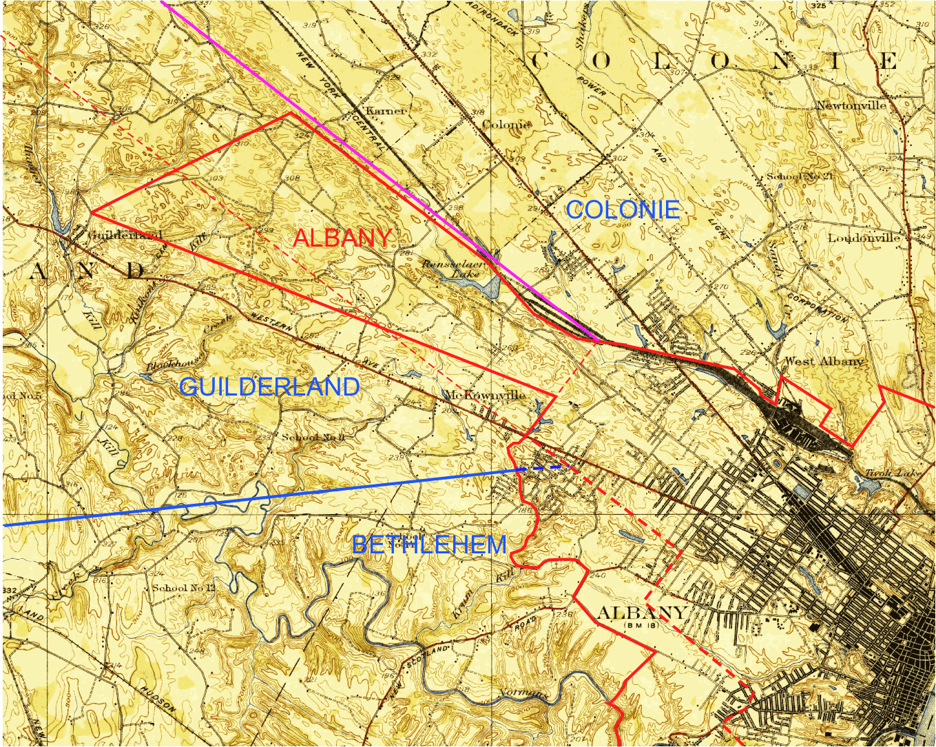
USGS 1927 Albany quad map annotated showing:
City of Albany boundary from 1912-1916 (red);
Guilderland-Colonie boundary 1896-1916 (magenta)
Guilderland-Bethlehem boundary to 1916 (blue)
former Albany-Guilderland boundaries:
(dashed red lines; thin - before 1871; thick - before 1912)
1916 - establishment of the present Guilderland-City of Albany
boundary:
- annexation of the
part of McKownville east of the Krumkill east branch to the City
of Albany
- annexation of
further areas of the Pine Bush in the Town of Guilderland to the
City of Albany

USGS 1927 Albany quad map annotated showing:
City of Albany boundary from 1916 (red);
Guilderland-Colonie boundary from 1896 (magenta)
Guilderland-Bethlehem boundary from 1803 (blue)
former Albany-Guilderland and Albany-Bethlehem boundaries:
(dashed red lines; thin - before 1871, and 1912; thick - before
1916)
former Guilderland-Bethlehem boundary:
(dashed thick blue line - before 1916)
minor changes after the 1916 annexations have been made locally
in the Albany-Guilderland boundary near Willow Street (Hamlet of
Guilderland) in
1981;
in the Guilderland-Bethlehem boundary east of the NY Thruway (Three
Hills Terrace)
view the current
Town of Guilderland zoning map for these adjustments
(the date of the Guilderland-Bethlehem adjustment has not been
identified)
1924 - petition by Three Hills Terrace residents for annexation
to the City of Albany (not successful)
The Altamont Enterprise reported that
some residents of Three Hills Terrace submitted a petition to the
City of Albany requesting annexation of their neighborhood to the
City. This request must have been unsuccessful as the area remains
part of the Town of Guilderland.
1955 - petition and legislative attempt for annexation of
McKownville to the City of Albany (not successful)
Significant dissatisfaction with the quality of the water supplied
by the McKownville Water District seems to have been the main motive
that caused a group of about 60 McKownville residents to petition for
annexation of McKownville to the City of Albany. This movement
was aggressively promoted by a columnist employed by the Times-Union
newspaper, who was a resident of McKownville for a few years. The
proponents clearly had the assistance of the mayor of Albany,
Erastus Corning 3rd, as his office drafted and submitted legislation
to enable this annexation. Fortunately, even though Corning was
accustomed to getting whatever he wanted, in this case the
opposition of a very large number of residents was so clearly
expressed (536 signed the counter-petition) that the Legislature
apparently took no action and the matter was quietly abandoned. A letter from
McKownville resident William Embler printed in the Altamont
Enterprise sets out clearly the disadvantages that the annexation
would have brought and shows why there was such a large majority
against it. A response
by Fred Abele to one of the Times-Union columnist's repeated
provocations also gives a good background to the concerns of the
residents, and the probable consequences of annexation.
The water quality issues largely were caused by careless
construction practices when the NY State Thruway was being built
1952-54, and siltation of the Krum Kill stream crossed by that
interstate highway a short way upstream of the McKownville
reservoir. The filtration plant could not cope with such repeated
heavy insults, and the reservoir was significantly reduced in volume
by the sediment deposited in it. The Water District and the Town of
Guilderland attempted to recover some recompense from the Thruway
Authority in order to dredge the sediment from the reservoir, and
provide maintenance and remediation to the filters, but that agency
first denied it had caused any significant problem, then stalled
repeatedly the process of determining the extent of the damage, and
in the end seems to have provided no, or very little, compensation.
The Town eventually, in 1964, solicited bids
to remove a large volume of sediment from the McKownville reservoir,
and nearly $30,000 was expended to remove over 10,000 cubic yards of
sediment.
They also spent about $50,000 adding more
filtration and pumping equipment the next year.
return to history page


