The Five Mile House, its location, and William McKown's lease
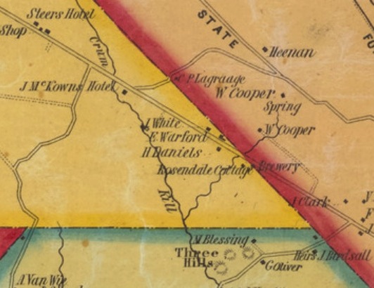
 Map made in 1939 by William
Efner, showing the former location of the Five Mile House,
Map made in 1939 by William
Efner, showing the former location of the Five Mile House,
then said to be located under the green of the 18th hole on the golf
course of the Albany Country Club. This tavern was leased by the
City of Albany to William McKown from 1787 to 1808. The symbol just
to the right of the tavern is probably meant to represent the well
sited in that position. No firmly identified pictures#
of the old Five Mile House are known to exist, but it is possible
that an 1889 photo of an old
farmhouse used for a few years by the newly formed Country
Club as its first clubhouse is of the Five Mile Tavern.
This map and other documents by W.B. Efner and W.D. Mohr used as
sources for this page are in the WD Mohr archive at the Albany Pine
Bush Preserve [organized and contributed by Steve Rider].
This tavern was the second hostelry going west along the "Kings
Highway", the original road between Albany and Schenectady, and the
main road until the Schenectady Turnpike opened in the early 19th
century. The tavern got its name from the location about 5 miles
along the road from the Hudson waterfront at Albany. The place was
known as "The Kuyl", an old Dutch word meaning*
"den", or "pit", but it is not known why this was applied. The
earliest record of the tavern is from 1767, when "John
Ritchies at the Knil" is the label for a building here on A map of
the Manor of Renselaerwyck by J. Bleeker, surveyor. In
1778, another map (Erskine-DeWitt map From Albany to Schoharie)
shows the building with the label "Michael Hornbeek". In April
1786, minutes of the City of Albany Common Council indicate that
William McKown is making repairs to it and permits him to put up a
barn, and to offset the repair expenses against his rent; in 1787
there is a formal
lease of the property, including 43 acres, to William McKown
for 21 years until 1808. The City of Albany's Journal of Receipts in
the NYS Library show that William McKown faithfully
paid his annual rent (£25 up to 1801, $62.50 after that) up to
the end of his lease of the Five Mile House, making the last payment
on July 4th 1807. It is probable that McKown subleased it when his
new Hotel and tavern on the Great
Western Turnpike became busy after the completion of this part of
the Turnpike in about 1800. A map
of 1805 in the Albany Institute of History and Art marks the
Five Mile House as "Daniel Woodworth's T.", who was a
brother-in-law, and McKown continued paying the rent to the City of
Albany. While William McKown established himself running the Five
Mile Tavern in the 1780's, his older brother James was also in the
same trade, building a
similar inn on the road to Kinderhook, about 5 miles east of
the Hudson River next to the East Greenbush town line.
W.D. Mohr wrote that he had seen a map in the office of the Albany
City Engineer, showing the Five Mile House annotated with the name
"Lewis" and "Lease expires May 1, 1819"; this must have been a copy
of the 1817
Van Alen map of the Great Lots, which shows this inscription;
that is the last known trace of this building in the old City
records.
Three mid-19th century maps show house locations in the area, the
earliest being the 1851 Sidney map, which shows the house William
Knowles later sold to the Club, located west of the east branch of
the Krum (Crum) Kill, belonging to W Cooper. The map shows another
house north of this one, also labelled with the name of W Cooper,
which might be the house the Club used as the first clubhouse. The
location shown is approximately where the Five Mile House ought to
be placed.
The 1854 Gould map only shows the southern of these two houses,
labelled belonging to W Cooper. The Beers 1866 map of the western
part of Albany does not show the Krum Kill stream, and does not show
the house later owned by Knowles, which we know was present. It does
show two houses on the Kings Highway, one labelled Knause, at the
location of the Five Mile Tavern, and the other J Archy, at the same
place as the house labelled Heenan on the 1851 map. See this web
page for maps
showing the relative positions of these marked houses in the
context of the Country club property and golf course, and the
positions of the Five Mile House and the King's Highway on the Van
Alen map.
Part of the 1851 Sidney Map of the vicinity of Albany and Troy,
showing the area of McKownville and surroundings.
The house that William Knowles sold to the Country Club in 1894 is
shown on this map, in the right place on the west side of the
Krumkill stream east branch, labelled with the name W Cooper
(William Cooper). Another house to the north, also labelled W
Cooper, is near the
location of the old Five Mile Tavern.
The first USGS
topographic map of this area, published in 1893, perhaps shows
a house present approximately at the site of the Five Mile Tavern,
but does not show anything at the nearby site of William Knowles
farm and house, purchased by the Club in 1894-5, nor any house at
the location farther west of the LaGrange farmhouse, both of which
certainly existed at the time of the map survey (1891).
There is a newspaper
report of 11 November 1914 suggesting that the Five Mile
Tavern (called King's Tavern in the article) still stood but in a
poor state of repair; then a one-sentence
report in a McKownville news paragraph published in the
Altamont Enterprise of 26 March 1915 states that the old Country
Club clubhouse burned down. If this was the Five Mile House, as
claimed in the 1914 report, that was the end of it, and it had
certainly been gone at least for decades by 1940, the date on William Efner's
research notes.
-----------------------------
# Fred Abele, in the Altamont Enterprise, 13
March 1981, p.3 stated: "A painting is the only known illustration
of what is reputed to be the tavern building which was demolished
shortly before 1900". The painting referenced has not been traced,
and the date of demolition is debatable (see above).
*In the same article, Abele says the location was at "the Kyl", and
that it referred to the east branch of the Krum Kill stream, which
rises near the tavern site. This might be plausible, as this is the
only place along the King's Highway where such a stream is close by.
However, the word used in most of the 18thC documents for this place
(except for the "Knil" on the Bleeker map) is specifically "the
Kuyl". Geoff Williams, the University at Albany archivist, indicates
this is an old Dutch word for a pit, which describes quite well the
steep-sided head of the channel of the stream that existed here
before the University construction. Another source translates it as
meaning "a den", but why this would have been attached to this place
is unknown; perhaps wolves
once lived here too?
[this page revised significantly 10/2024]
return to McKownville
older buildings photo index page
return to McKownville Improvement
Association index page