J A McKown and the McKown gravestones; and the Jackson (or Van
Valkenburgh) Tavern
The original gravestones from the McKown family graveyard, once
located behind William McKown's McKownville hotel site, were found in
1973 making up part of the cellar floor of an old house near
the Prospect Hill Cemetery, just before that house was demolished.
This old frame house was sited where the SEFCU credit union building
now stands, and was on the west bank of the Kaikout Kill brook (now
covered over here). Why should these stones have been carefully laid
to form the cellar floor of this particular house?
The old maps
On the 1851 Sidney map, the house is shown with the name of J McKown
attached to it by a dotted connection line; the Hotel (known as the
Jackson Tavern) just up the hill to the west is labelled "Hotel"
with a similar connection line, but does not have any person's name
directly attached to it.


On the 1854 Gould map, the names are not given connecting lines to
the same two house symbols, so there is an ambiguity about the
labels for these structures; it could be read as Hotel (belonging
to) J A McKown and the other building unlabelled, or it could be
taken to mean the same as on the 1851 map, that J A McKown is the
label for the house nearer to the Kaikout Kill, separate from the
Hotel.

On the 1866 Beers map of Guilderland, the labelling (also names
only, without indicator lines) suggests that J McGowun is the Hotel
owner, and the other house near the Kaikout Kill is unlabelled. The
map shows that William Knowles owned the house on the north side of
the Turnpike, earlier occupied by Shubel Kelly, who had moved and
owned two houses near the crossroads to the east (now the Rte 155
intersection).
Census returns
Who is this J, or JA McKown? Alice Begley stated
that it was James son of William (Billy) McKown (1763-1843), but
William's only son named James died in 1796 at the age of 5, so that
cannot be right. Perhaps she meant John McKown (1787-1870), eldest
son of William, but that John lived in a large farmhouse
on McKown Road, and was owner of the McKown Hotel in
McKownville. Along with his son James F McKown he ran that
institution and the associated farms in McKownville and near the
Normanskill during this interval. There was another John A McKown
(1811-1864), eldest son of Absalom McKown (Absalom was William
McKown's second son), and another alternative is Absalom's younger
son James A McKown. Census records of 1850 and 1855 list James A
McKown in Guilderland among other individuals shown nearby on the
maps. He is listed as a farmer in 1850, even though he and his
brother John A were both lawyers, and he became Surrogate judge for
Albany County in 1855; he is listed as justice of the peace in the
1855 census. His brother John A, in contrast, had already moved and
by 1855 was living in Albany. The later 1866 Beers map still labels
J McKown (McGowun) as owner, of the hotel, and perhaps also of the
house, but James had by then also long since moved to Albany, in
1856, according to a published
biographical sketch.

1850 US census listing for James A McKown, pages 35-36 in the Town
of Guilderland enumeration. His household is immediately preceded by
Shubal Kelly (Kelley), who is marked on the 1851 Sidney and 1854
Gould maps directly across the Western Turnpike from the JA McKown
house.

1855 NY census listing for James A McKown, page 1 of the 1st
district of the town of Guilderland enumeration.
Living in a framed house (first column), valued at $550.
The column (9) containing "Albany" is the county of birth.
Numbers in column 12 are years resident in this city or town.
 James A McKown's residence
It is most probable that the J A McKown on the 1854 map is James A
McKown, son of Absalom, and that the J McKown of the earlier and
later maps are likely also referring to him. Given that the 1851
Sidney map clearly shows his name attached to the house in which the
gravestones were found, it seems likely that they ended up there
because of the family connection, if not an agreement. If the stones
were moved in 1865, which is when the cemetery records state that the remains
were reburied, no McKowns themselves lived above the gravestones of
their relations taken from McKownville.
There is a biographical
sketch of Judge James A McKown in a book on Albany County
history published in 1897, Landmarks of Albany County, New York by
Amasa J. Parker, accompanied by this portrait engraving.
Deeds for this property show that
from 1874 it was owned by John Newman, and from his death in 1915 by
his daughter and son-in-law Matthew and Ada Zorn. Their heirs sold
the Zorn's farmland and this house in 1964. The Regency Park
developers obtained it in 1971.
Fred Abele reported
that this house was at one time occupied by caretakers for the
nearby Prospect Hill Cemetery, and that it became unoccupied by
about 1963. It was demolished in 1973, unrecognized as a house once
probably lived in by a distinguished member of the McKown family.
Possibly it may have been the original farmhouse of Absalom McKown,
father of James A McKown, and brother of William McKown of
McKownville.

The "Jackson" Tavern
This building is the one marked as a hotel, next to J(A) McKown's
name, on the old maps above. It was built in
the early 1800's, one of a considerable number of hostelries
built to serve the traffic on the new Great Western Turnpike, like the hotel and tavern
built by William McKown, farther east, in McKownville. It
seems unlikely that it would be so labelled on all three of these
maps unless it was an active hostelry and tavern at the time of
their survey, and that sort of building seems an unlikely residence
for James A McKown and his family, a justice of the peace in
Guilderland from 1837-1855, although it is now clear that his wife
Alida became the principal owner after her mother died, in 1848.
There were two other hotels nearby, one a large brick building
located just east of Foundry Road on the south side of the Western
Turnpike, known as Sloan's Hotel, and the other just east of the
crossroads where route 155 now crosses Western Avenue, on the north
side, which is shown on the early maps as Folland in 1851, LaGrange
in 1854, and perhaps Mochrie in 1866. Sloan's and Folland's are
identified as hotels with innkeepers of those names in the 1850
census, but the Jackson Tavern is not identifiable in this census.
Perhaps James A McKown was using it as his residence, but that would
make the clear labelling as a hotel on all three maps puzzling.
Deeds for this property when
sold in 1867 reveal a connection between James A McKown's wife,
Alida, who then, in her own right, was the principal owner, and her
sister by then Hannah M Jackson, who owned adjacent property,
part of it jointly with her sister. Alida and Hannah M were two of
the daughters of Francis Van Valkenberg, and a third daughter,
Edith, lived with James and Alida McKown for much of her life.
Hannah M is listed in the 1850 census extract shown above, not yet
married and also living with the McKown family. Presumably not long
after that she married the Mr Jackson who was leasing this tavern.
The 1867 deed states that she was by then living in Albany.
Tracing the ownership of this property in earlier deeds, and wills, it is
apparent that Francis Van Valkenburgh purchased in 1806 the part in
which the Tavern was built, from John and Jacob LaGrange; John
LaGrange being his father-in-law. The Great Western Turnpike opened
in 1800, and perhaps the LaGranges built the Tavern before they sold
this land. Whether Francis Van Valkenburgh built it, or just bought
it, he most likely did run this tavern, and farmed the adjacent ~60
acres which he also came to own, from 1806 until his death in 1833.
His widow Hannah may have continued to operate it until her death in
1848, or it may have been rented; the 1850 water supply map below is
good evidence that one Jackson was the tavern operator renting it at
that time. The Van Valkenburgh daughters Alida (who married James A
McKown in 1837) and Edith continued to own the Tavern property, and
the younger surviving daughter Hannah Margaret the adjacent
property, until sold in 1867. So despite historical articles written
much later, with the name based on the label in the 1850 map, this
Tavern ought to be called the Van Valkenburgh Tavern, after its
original owner, and perhaps builder.
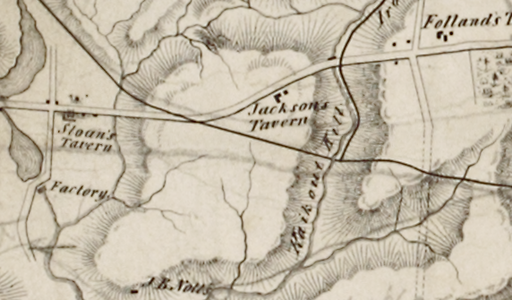 The 1850 map made for
proposed City of Albany water supply shows it labelled as Jacksons
Tavern; Sloan's, and Folland's Taverns are also shown. Deeds from 1867 show a
succession of owners of the "Jackson" Tavern; Lawpaw (1867), Strope
(1870), Oliver (1887), Cotton (1888), Mapes (1893), Kelderhouse
(1898), Hine (1907).
The 1850 map made for
proposed City of Albany water supply shows it labelled as Jacksons
Tavern; Sloan's, and Folland's Taverns are also shown. Deeds from 1867 show a
succession of owners of the "Jackson" Tavern; Lawpaw (1867), Strope
(1870), Oliver (1887), Cotton (1888), Mapes (1893), Kelderhouse
(1898), Hine (1907).
In 1922 it was sold to Ellen Smith and became a farmhouse, for the
Smith's of the Prospect Hill Dairy, which was active until about
1980.
In a familiar and depressing story, the building was empty for
the last 15 years of its life at this site. Purchased as part of a
larger tract by a developer, it narrowly avoided demolition, instead
being
dismantled carefully in 1996, with the intention of
reconstructing it as part of a collection of historical buildings
planned for a site near Cooperstown.
return to McKown family tree and
gravesites
return to McKownville local history
page
return to McKownville Improvement
Association index page