McKownville
Improvement Association
- Some McKownville history, and the houses of
McKownville [pdf - printable version]
William McKown (1763-1843), starting in 1797, bought several hundred
acres of land across which he knew the Great Western Turnpike
would be constructed (later called the Great Western Plank Road, now
Western Avenue, US Route 20). He built a hotel and tavern on a site
that proved to be ideally situated next to the south side of the new
road, about five miles west of the Hudson River shore at Albany,
located at the present intersection of Fuller Road and Western
Avenue. The McKown
hotel was ready for the opening of the eastern section of the
Turnpike in 1800, and was a focal point in the 19th century of the
small community which grew along this part of the Western Turnpike.
William McKown was one of the prominent citizens of the Town of
Guilderland, being elected Town Supervisor 1813-1824, and the
Guilderland representative on the Albany County Board of Supervisors
from 1818-1824.
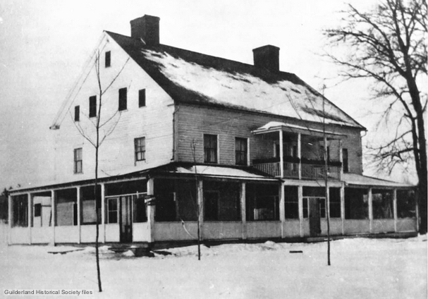
William McKown's hotel and tavern, built c.
1796-9. The location became the south side of the Western Turnpike
at the intersection with Fuller Road. This building burned down in
1917; the petition
to Albany County to establish the McKownville Fire District was
submitted very soon after this event.
The McKown hotel was leased in 1884, from the heirs of William
McKown's eldest grandson (William J McKown, 1811-1879), by William H
Witbeck, who with his family members ran the business until two
months before the hotel burned
down in 1917.
William H Witbeck in 1907 purchased the hotel and 184 acres from the
William J McKown heirs, extending both east and west from the hotel
lot and on both sides of the Western Turnpike, between the present
Knowles Terrace and Church Road. He started to subdivide and sell
lots from this land in 1909, but soon after sold most of it to a
business partnership of his son Benjamin F Witbeck and Arthur F
Pitkin. This partnership, later becoming the Pitkin-Witbeck Realty
Corporation, made a revised subdivision of the 40 acre area north of
Western Avenue and east of Fuller Road, calling it "Country Club
Highlands", and sold lots in this from 1913 onwards. Most of the
lots were sold and the houses built in this subdivision between 1914
and 1930, and by the end of 1937 only a few remained unfilled,
mostly in the western part of the area on Parkwood and Elmwood
Streets.
At the east end of the McKown land, on the north side of Western
Avenue, William J Knowles in 1894 purchased 2 acres from Katherine
McKown, and from Henry Drumm an adjacent 1 acre and his house.
These lots combined became the Knowles Terrace subdivision, with the
lots sold and houses built from 1917 to 1926. William Knowles bought
this property and moved here in late 1894 because he sold his
previous house and farm to the newly established Albany County Club,
with his former house, after architectural improvements by Marcus T Reynolds, becoming the club house.
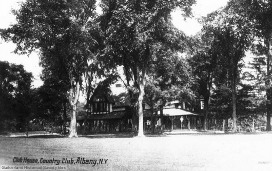
Clubhouse of the Albany Country Club, formerly
the farmhouse of William J Knowles, but architecturally renovated
and enlarged for the newly established Club by Marcus T Reynolds
in 1895-6. Burned down in 1963, not long after the Club land was
sold for construction of the new campus of the State University of
New York at Albany.
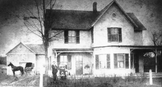
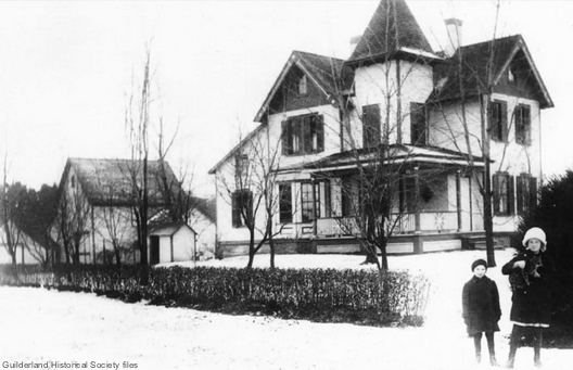
The house of William J Knowles about 1898, which still
exists at 1261
Western Avenue at the eastern corner of Knowles Terrace and
Western Avenue. The picture shows him, his second wife Caroline,
their son William J Knowles jr about 4 years old, and his mother
Hannah (age about 92) in the rocking chair next to the front door.
Built by Henry and Andrew Drumm c. 1879.
William Knowles died in 1912, and his widow Caroline continued to
live at Knowles Terrace until about 1926; she then moved with her
son William J Knowles jr and his wife Margaret to the old McKown
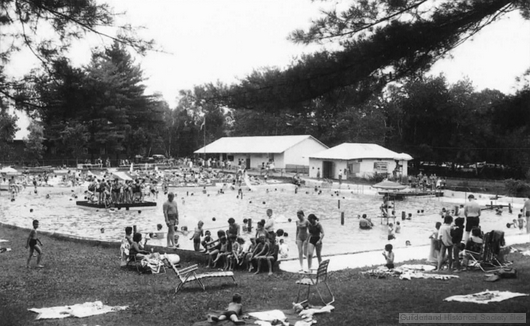
farmhouse on McKown Road, where they operated McKown's Grove.
This included a large swimming pool fed by the west branch of the
Krumkill stream, a picnic grove, a baseball field, and a dance hall.
This place provided much enjoyment for McKownville residents until
1973, also hosting community events, including McKownville Fire
Department annual picnic.
McKown Grove swimming pool (1958 picture).
William McKown opened the Grove in 1896; William Knowles jr
purchased it about 1926, and he ran the business until his death
in 1948; his widow Margaret sold it in 1950. It closed in 1973,
after fire damage to the dance hall, and soon after all the
buildings were demolished and the swimming pool filled in.
East of the Knowles Terrace land, on the north side of Western
Avenue, there is a 1 acre lot of mostly low-lying ground. This lot
formerly was occupied by a house (1257 Western Avenue)
built in or before 1890. The house was owned from 1910 for a long
time by Alfred Garrison, a founder member of the McKownville Fire
Department. It was demolished in 2004 after becoming derelict, and
the lot now belongs to the Town.
East of this lot there are nine houses on the north side of Western
Avenue which occupy land once the property of Charles Gimlick, who
purchased 11 acres and a house in 1881. Seven of these houses were
built in 1921-1925 on lots sold by Charles A Gimlick, his son.
Another was built earlier in 1912 on the easternmost lot (the house
still present at 1239 Western Ave). The oldest house in this row is
at 1245 Western
Avenue, a Federal-style brick structure. The deed selling this
house and the 11 acres to Charles Gimlick in 1881, and the earlier
deeds to former owners, imply that the older core of it was built in
1850 by Eli Warford. It is marked with Warford's name beside it on a
map published in 1851 (Map of the
vicinity of Albany and Troy, by J.C. Sidney), and it also
appears on the 1866 map of Guilderland included among the Beers' maps
of Albany County, marked with the name of the owner at that time,
Jacob Sager. This house is without doubt the oldest surviving
structure in McKownville.
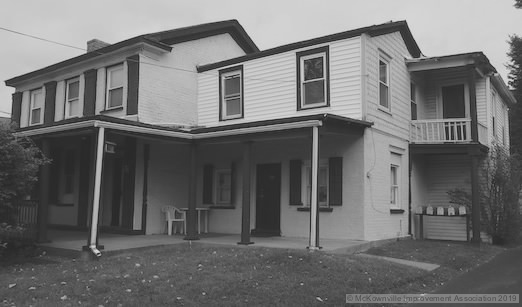
The Federal-style brick house at 1245 Western Avenue. Built by Eli
Warford in 1850; occupied by Jacob Sager 1864-1870; sold to
Charles Gimlick 1881. The oldest surviving house in McKownville.
The McKownville Volunteer Fire Department was
formed in 1918, and celebrated its 100th anniversary with a splendid parade in June
2018. From 1926, it housed its "chemical engine" in the Country Club Garage,
located on the south side of Western Avenue at the west corner of
Hillcrest Avenue. In the mid-1930's, a classic
one-engine firehouse was built facing onto Arcadia Avenue,
designed by the architect August Lux, a longtime McKownville
resident (6 Elmwood Streeet). The present firehouse at the
intersection with Brookwood Avenue dates from 1967, and was also
designed by Lux; the distinctive weathervane originally on the
cupola of the older building was moved to the new one.
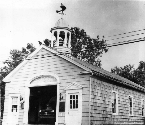
The old McKownville FD firehouse; designed by August Lux and
opened in 1935. (photo from 1950's).
On the east of McKown Road, set back from Western Avenue, there is a fine Queen
Anne-style house which was built originally much closer to
Western Avenue on the east side of McKown Road. It was moved in
1948-9 to a new foundation and the present undistinguished garage
replaced it on the corner. Until 1981, there was an identical
matching house opposite on the west corner of McKown Road. After being used by the
Huckleberry Finn housewares and furniture business, it was
destroyed and replaced by a utilitarian paint store. The house on
the east side was built by William McKown (1842-1924; the
great-grandson of the first William McKown) about 1887; in 1920 he
and his two daughters Anna and Eva were living in it; the daughters
remained here until 1948. The one on the western side (1438 Western
Ave - see picture below) was built in 1891, and was the home for
many years of George and Ida Manville, and then of George and
Florence Crouse before the Huckleberry Finn business occupied it in
1964. An attempt was made in the 1980's to place the surviving house
on the National Register of Historic Places, but the proposal failed
because the owner opposed it. The house was placed on the NY State
Register of Historic Places.
The Queen Anne-style house that used to be on the west side of
McKown Road at the intersection with Western Avenue, 1438 Western
Avenue. The home of George and Ida Manville when the picture was
taken, about 1917; the children are probably Helen and Jeanette
Manville.
William Barnes jr was an Albany newspaper
publisher and influential Republican political fixer between about
1890 and 1920. In 1909 he purchased a five acre plot in McKownville
adjacent to the Albany Country Club and had a "Lodge" built among
the pine trees, on top of one of the vegetated sand dunes of the
Albany Pine Bush. The lot was not part of the Country Club Highlands
development, but the Barnes
Lodge was accessed by a driveway from Waverly Place, one of
the streets in that area opening onto the north side of Western
Avenue. Barnes sold in 1920, but the house remained a desirable
residence until 1965 when it was sold to the Capital Area Council of
Churches, who used it as a multi-faith facility for the then new
adjacent campus of the State University. It burned down in 1985, but
it is still (2022) listed, as "Chapel House", on the National
Register of Historic Places!
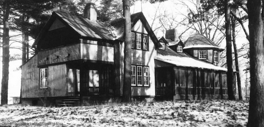
The Barnes Lodge, built 1909; a private residence until purchased
by the Capital Area Council of Churches in 1965. Used as a
multi-denominational Chapel House for the adjacent campus of
the State University at Albany until
destroyed by fire in 1985.
The moving Guilderland-City of Albany boundary
William (Billy) McKown (1763-1843) possessed land that adjoined the
original southern boundary of the City of Albany; this
northwest-trending boundary was known as the "Corporation", or
"Bleecker" Line. This line can still be seen on present-day property
maps of McKownville, defining the northern boundary of the original
"Country Club Highlands" development, and separating this older part
of the Elmwood Street to Waverly Place area from the post-1945
developments of the northern parts of the four "wood" streets. It
also forms the northern boundary of the northern lots of Knowles
Terrace, and of the lots in the area east to the City of Albany-Town
of Guilderland line on the north side of Western Avenue. This
"Corporation" Line is no longer the City of Albany line, because the
boundaries of the City of Albany were changed, three times, in the
later 19th and early 20th centuries. The Town of Guilderland, and
McKownville, first gained a significant area from the City of Albany
and then, after about 40 years, was compelled to give most of it
back.
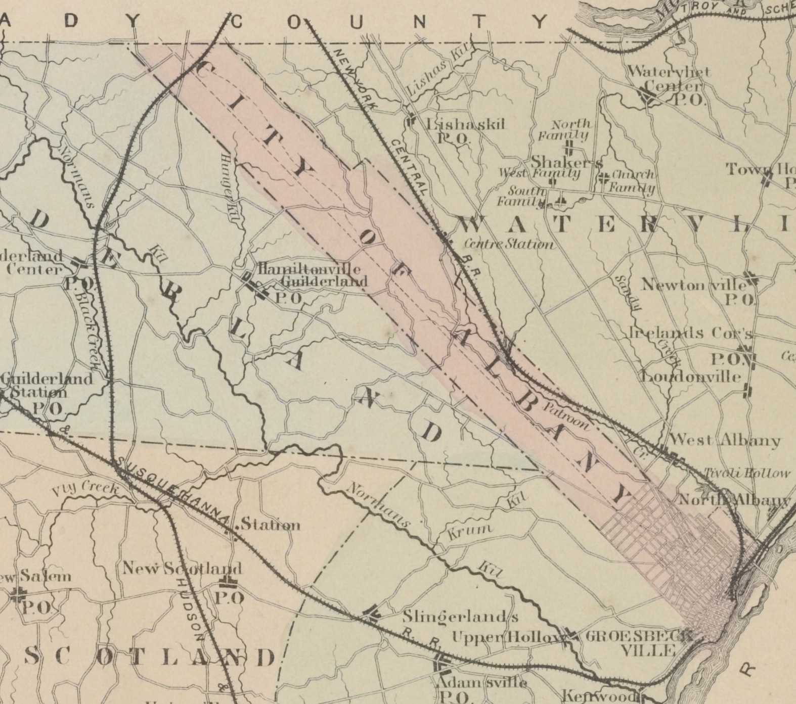
Part of the map of Albany County in the 1866 map
portfolio of Beers. This shows the original City of Albany area
(in red tint) with boundaries extending all the way northwest to
the Schenectady County line. The southwestern boundary with
Guilderland on this map is the "Corporation" Line; this defined
the northern side of William McKown's property.
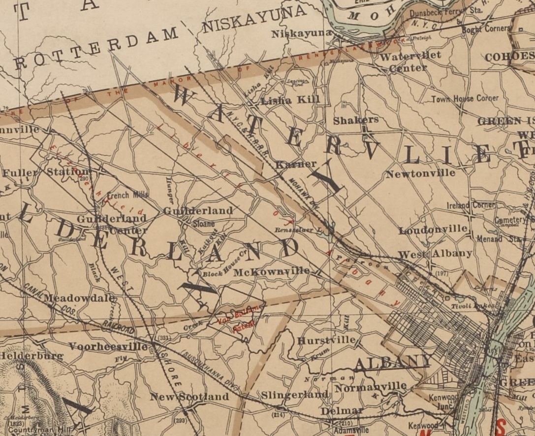
Part of the map of Albany County in the 1895 map
portfolio of Bein. This shows the truncated City of Albany, and
the expansion of Guilderland to the Watervliet boundary (later the Colonie
town line).
In 1871, the parallel-sided area of the City of Albany that extended
west all the way to the Schenectady County line was cut off by a new
boundary, running at a right angle to the Corporation line from the
position where it crosses Western Avenue, a short distance east of
the present University entrance. All the area northwest of this new
boundary up to the Watervliet (now Colonie) line was given to the
Town of Guilderland.
Soon after 1900, the political powers of the City of Albany decided
that this was all a big mistake, and in 1910 a large piece of this
land was cut out of Guilderland and taken back into the city of
Albany, and in 1916 enlarged a bit more to the presently defined
boundaries. During this process of political reorganization, there
was an additional loss imposed on McKownville in 1916; the roughly
triangular area east of the Krumkill and south of Western Avenue to
the Town of Bethlehem line, which had never previously been part of
the City of Albany, was also annexed. Guilderland, and McKownville
once extended nearly to Russell Road, and pre-1920 censuses include
the persons who lived there in McKownville. Bethlehem lost a much
larger area, with no previous gain.
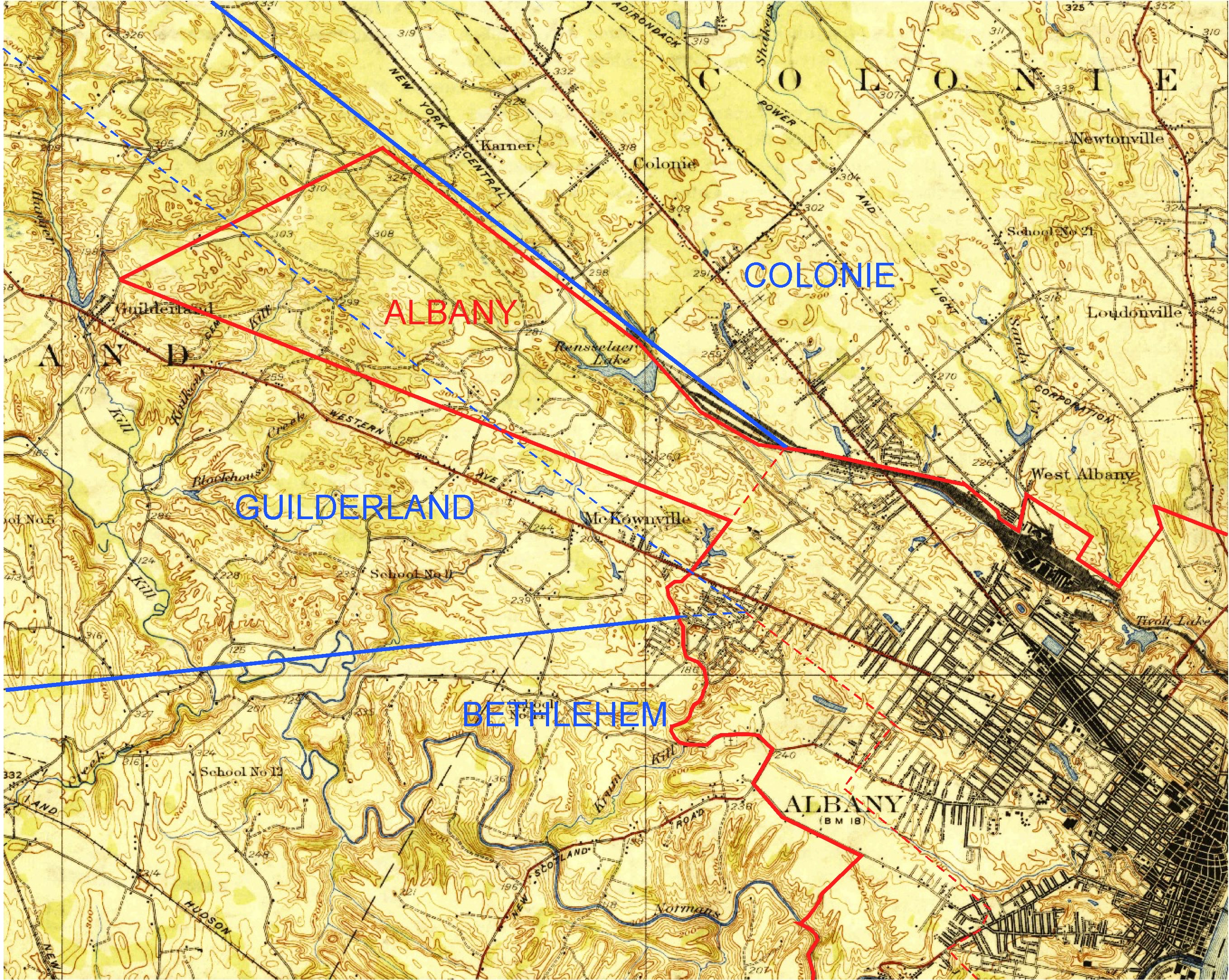
Part of the 1927 USGS map of the Albany
quadrangle, with the town and city boundaries emphasized. Blue -
Town of Guilderland; Red - City of Albany. Red dashed line shows
the former position of the City boundary before the change to the
present arrangement in 1916. Blue dashed line shows the position
of the Guilderland-City of Albany boundary before 1871.
Historical pictures used on this page are from the archives of the Guilderland Historical Society. They and many
others from elsewhere in Guilderland can be found in the book Images
of America - Guilderland, New York, Begley, A., and Johnson,
M.E., Arcadia Publishing, Charleston, South Carolina, 1999.
Historical maps of New York are easy to find and view on the
excellent New
York Public Library website.
Information about historic McKownville can be found in the local
Albany County newspaper the Altamont Enterprise, and in
particular the articles written by Fred Abele in the 1970's and
early 1980's contain much of interest. The website New York Historic Newspapers contains the full
searchable set of this publication from 1884; these can be accessed
through the Guilderland Library website.
Return to Mckownville Improvement
Association index page