McKownville
Improvement Association
- The Great Western Turnpike, and McKownville
The Great Western Turnpike was the ancestor of US Route 20, now
Western Avenue in McKownville and the adjacent City of Albany.
William (Billy) McKown's canny anticipation of the building of this
road to Cherry Valley, most likely based on insider information, is
the origin of McKownville. He sold the right-of-way through his land
to the Turnpike Company for 6
cents, with the restriction that the road must be built on the
surveyed line. McKown's
large hostelry and tavern was constructed
right next to this line, ready for the opening in 1800 of this
eastern section of the Turnpike. This establishment provided
refreshment and
accommodation to travellers, and their horses, and to droves
of cattle and other livestock, for which McKown built extensive
stockades and barns near the hotel on both sides of the road, and a
water system using pine log
pipes. A newspaper
article from 1928 contains a section that gives a good
description of this early 19th century enterprise, and its
connection to livestock markets in Boston and New York City (and
reveals that the hamlet then had a different name). McKown's
hostelry, like some others along the Turnpike, also served as an
informal post office, and became the location of the McKownville Post
Office from its formal establishment in 1862 until it was
closed in 1905.
Tollgate No. 2 on the Turnpike, 1890's; its location was in present-day
Westmere
(image from Guilderland Historical Society files)
This road was a privately funded, shareholding venture, with tolls
charged at numerous gates along the way. After the Erie Canal opened
in 1826, and even more after the railroads started to grow, after
about 1840, the turnpike failed to compete with them for
long-distance transport of people and farm products. It may never
have been particularly profitable, even before the competition
arose. In 1849 the section between the start of Western Avenue in
the City of Albany and the hamlet of Guilderland 8 miles west,
passing through McKownville (1851 map), was
improved with new investment by turning the south half into a plank
road, and the renaming of it to the Great Western Plank Road. As it
in turn became an unprofitable business, maintenance was inadequate
and eventually abandoned. Travelling on the road in the later 19th
century was an unenjoyable experience. Local government took over
the road in 1906, and some maintenance was then provided. It became
part of the national road network as US Route 20 in 1925.
A local newspaper (that titled
itself "The Turnpike Record") published in 1956 a summary of the
history of the Turnpike and Plank Road written by W.H Mohr,
and an extended series of articles by A.H. Gregg [text
transcript pdf; scan images pdf]
on the history of the Great Western Turnpike was published in
1957. Gregg included two of Henry Schoolcraft's tales of the
wolves that could still occasionally be encountered in the earliest
1800's when travelling through the pine forest on the road west of
McKown's hotel. The map of 1854 below
shows "Wolf Hills" about half a mile south of the Turnpike along
what is now Johnston Road.
Tollgate No. 1 on the Turnpike; view to the west of the rutted
snow on the Western Turnpike, 1890's
(original image source not identified; posted in
www.flickr.com/photos/albanygroup/)
The Turnpike has another link to McKownville; the last toll
collector for Gate No. 1 was a local resident, William J. Knowles
(1833-1912). Tollgate No. 1 was first situated
near McKownville (at the location of the present Homestead
Avenue intersection), but was replaced in 1849 by the one shown in
this photo, located at Winthrop Avenue, west of the intersection of
Madison and Western Avenues in Albany.
William Knowles lived on a farm that he sold to the Albany Country Club
in 1894, and then moved in 1895 to a house still standing at the
eastern corner of Knowles Terrace, 1261 Western Avenue. There's a photo of him and his
family at that house taken in 1898. He might have been the
first commuter living in McKownville, 2 miles walking or by horse
each way to and from this tollgate.
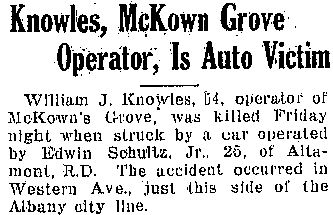
His son, also William J. Knowles (1894-1948),
purchased McKown Grove in 1926
and ran that business until his death in 1948, struck by a car on
Western Avenue (clip from Altamont Enterprise 26 November 1948) .
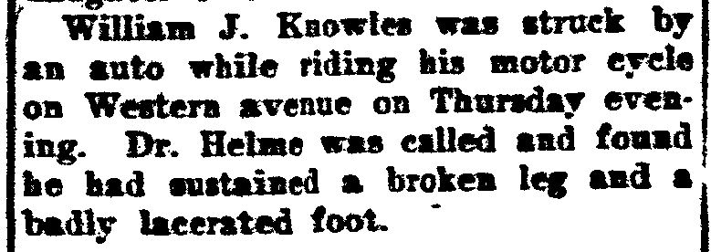 He had an earlier involuntary
encounter with a car on Western Avenue in 1914, riding a motorcycle
at the age of 19, getting a broken leg from that incident (clip from
McKownville news in the Altamont Enterprise 14 Aug 1914).
He had an earlier involuntary
encounter with a car on Western Avenue in 1914, riding a motorcycle
at the age of 19, getting a broken leg from that incident (clip from
McKownville news in the Altamont Enterprise 14 Aug 1914).
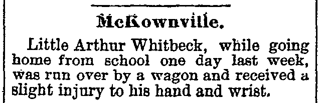
Not that the Great Western Turnpike before the coming of cars was a
safe place, either; this clip from the Altamont Enterprise of 5
April 1895 records a lucky escape for William Witbeck's second son
Arthur, age 8, walking the few hundred yards from the schoolhouse
to McKown's Hotel,
which his father had been leasing since 1884.
In 1897 the city of Albany had prevented the
Turnpike from blocking traffic using city side streets and bypassing
the collection at tollgate No 1.
The eastern 9 miles of the Western Turnpike passed in 1906 into the
ownership of the United Traction Company, and collection of tolls
ceased [an interesting detailed history of these
events]. The two miles of the northern 66 foot width of the former
Turnpike in the city of Albany was given to the city, and soon paved; the same width of the
remaining 7 miles in Guilderland was given to Albany County. The
southern one-third of the width of the Turnpike was reserved for a
trolley (tram) line. This was only built as far as the present City
of Albany-Guilderland boundary, and as just a single track, with
service to this point started in 1911. The UTC operated these
trolleys to the city boundary on Western Avenue only until 1925;
after that a bus service was substituted, including hybrid gasoline-electric vehicles for a short
time.
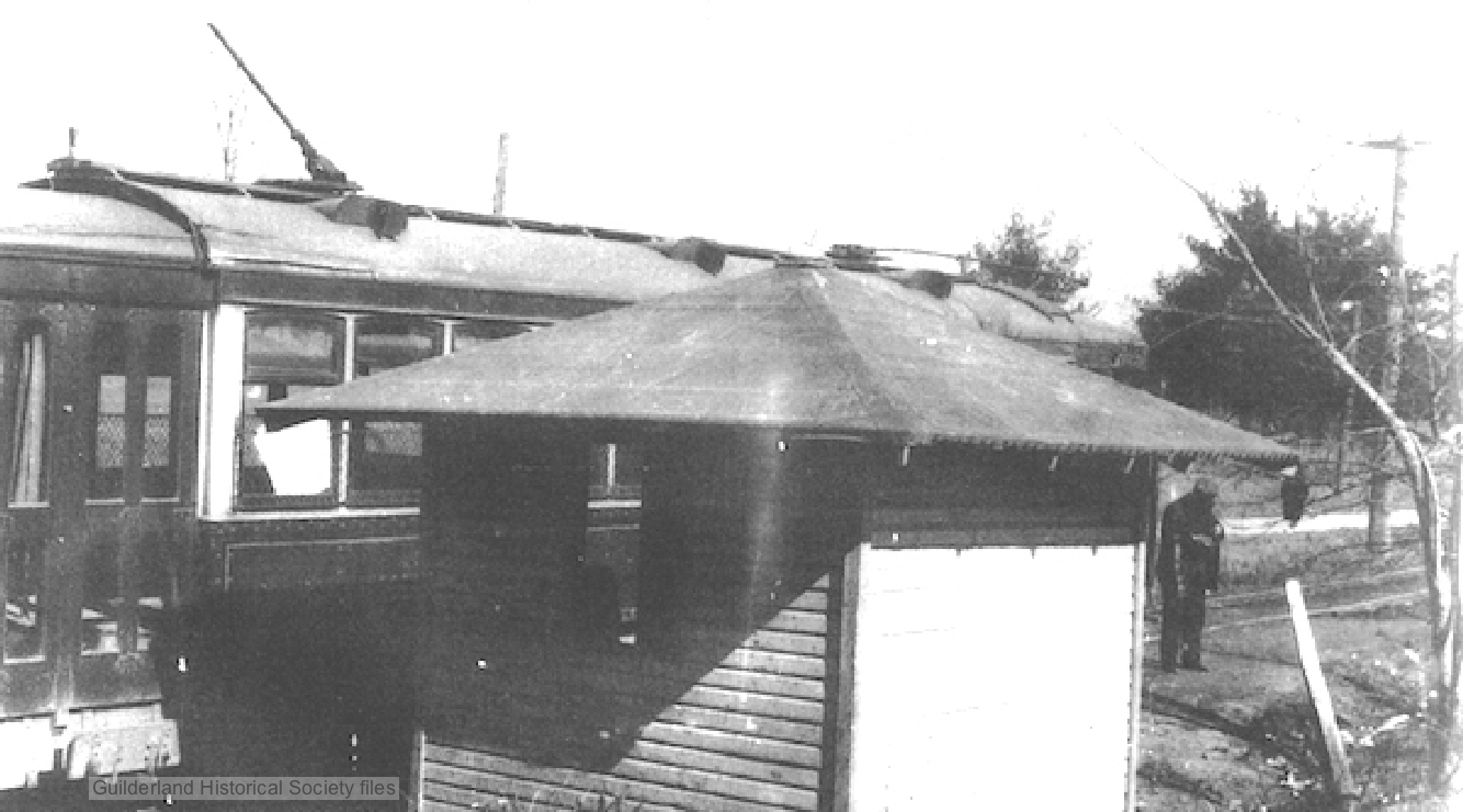
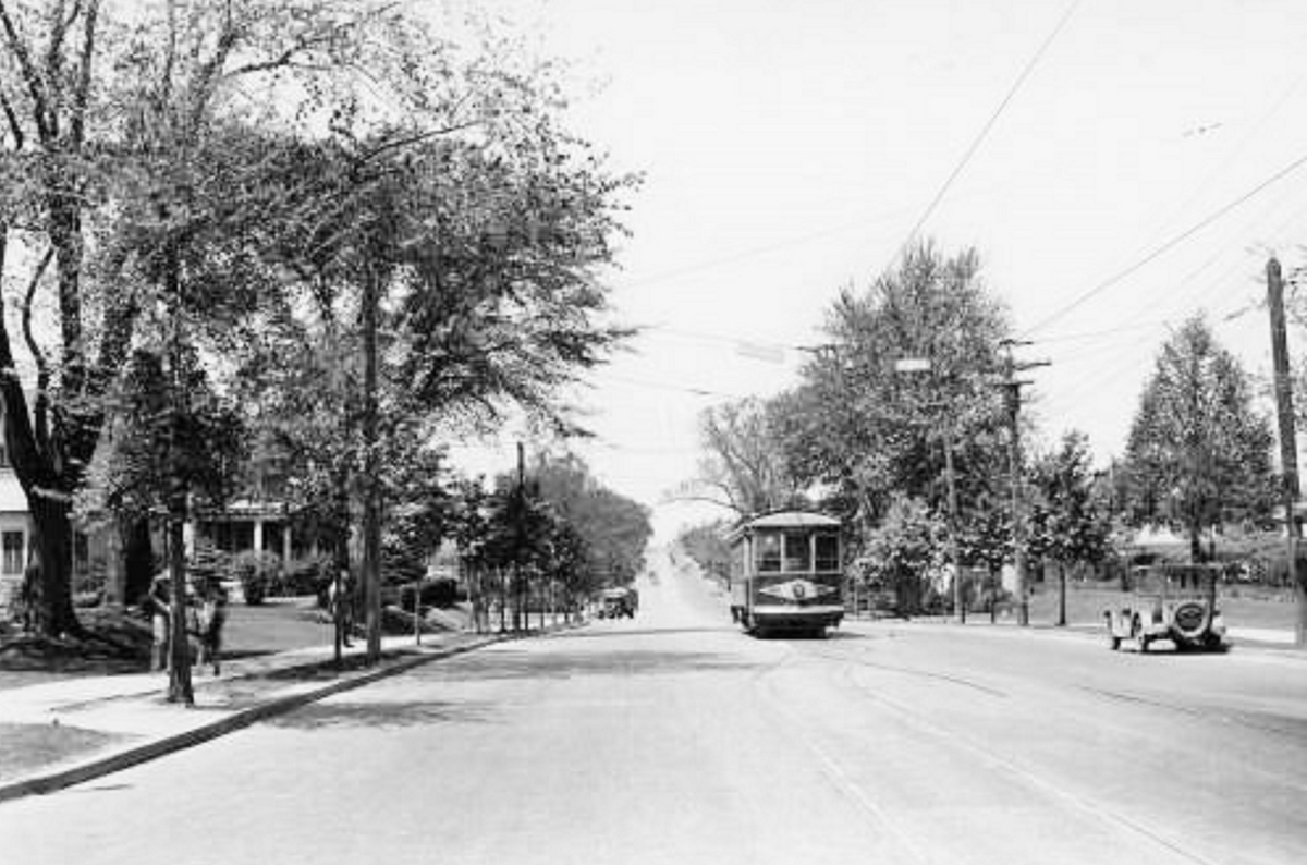 United Traction Company
trolley (left) at Country Club stop, the end of the Western Avenue
line at the City of Albany-McKownville/Guilderland boundary,
1920-25. (image from Guilderland Historical Society
files)
United Traction Company
trolley (left) at Country Club stop, the end of the Western Avenue
line at the City of Albany-McKownville/Guilderland boundary,
1920-25. (image from Guilderland Historical Society
files)
(right) on Western Avenue near the Manning Boulevard intersection,
view to the west, also 1920-25.
(original image source not identified; posted in
www.flickr.com/photos/albanygroup/)
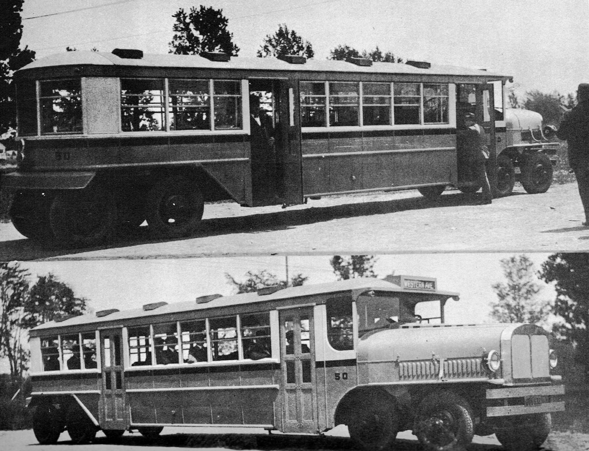
(left) Versare gas-electric hybrid 4-axle
bus used by United Traction Co on Western Avenue route from 1926
(this monster had a top speed of 30mph!)
(original image source not identified; posted in
www.flickr.com/photos/albanygroup/)
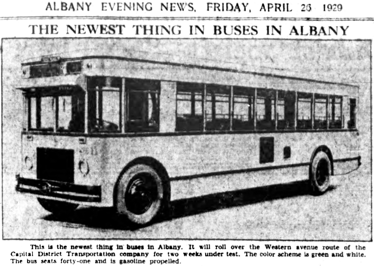
(right) ACF Metropolitan bus tested for Western
Avenue route; clip from Albany Evening News 26 April 1929
(posted in www.flickr.com/photos/albanygroup/)
later history of Western
Avenue and Route 20 in McKownville, from 1925
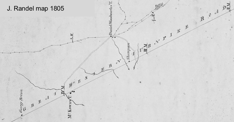
section of map of John Randel 1805 showing McKown's T(avern) next to
the route of the Great Western Turnpike Road
Used with permission of the Albany Institute of History and Art
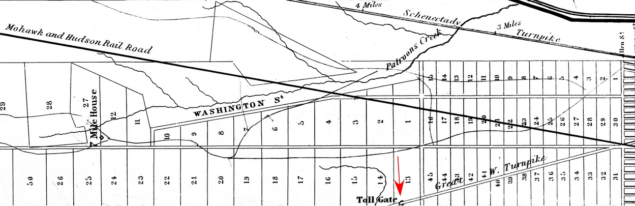
section of 1842 map by J. Bradt showing position of the original
Tollgate No. 1 near the Albany City line just east of McKownville
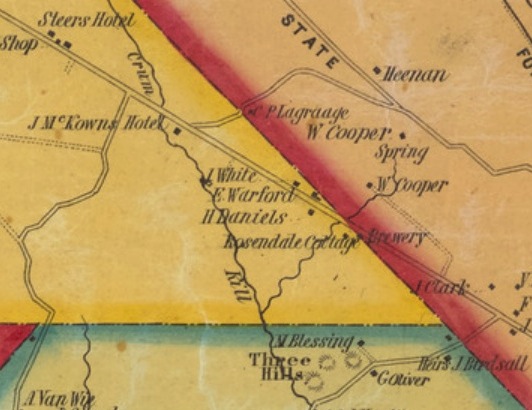
area of McKownville on the 1851 Sidney map, showing McKown's hotel
on the south side of the Great Western Turnpike at the Crum (now
Krum) Kill stream. John McKown (William's eldest son and heir) is
the individual referenced on this map as the hotel owner. The
brewery marked at the Guilderland-Albany line was Amsdell's.
Tollgate No. 1 had been removed in 1849.
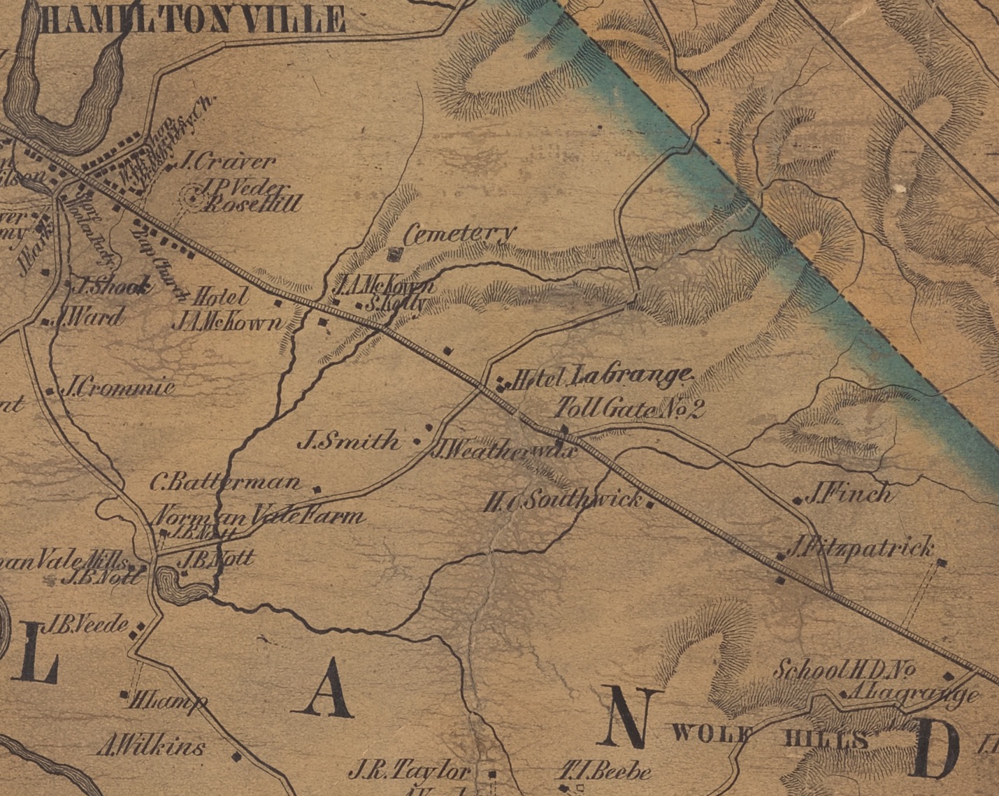
Part of the Gould map of 1854 showing the section of the Great
Western Turnpike from the present Johnston Road intersection to the
hamlet of Guilderland (then called Hamiltonville) at the present
Foundry Road/Willow Street crossing.
Wolf Hills are marked along the present Johnston Road, and Toll Gate
No. 2 a short way east of the crossroads that is now the Route 151
intersection.
The JA McKown marked on both sides of the road farther west was James A McKown, a nephew of William
(Billy) McKown. The cemetery nearby is the Prospect Hill Cemetery.
The first paving of Western Avenue into
McKownville was described, among much other evidence of corruption
in Albany, in an article titled "Mr.
Barnes of Albany", published in Colliers Magazine in 1912. The
pertinent part reads:
"There is a brick street pavement, built at the expense of the
taxpayers of Albany, from the heart of the city out to the country club
and to Barnes’s country
bungalow. Two hundred and twenty-five feet of this pavement
extends beyond city limits. For two miles, on the north side of this
paved avenue, there are seven dwelling houses, and on the south side
there are fourteen dwelling houses and an ice house. Forty thousand
dollars of bonds were authorized by the city council for this
Boulevard de Triomphe, dedicated to the convenience of Barnes and
his friends. The boulevard might have been paved with some other
substance but for the fact that one of Barnes’s henchmen is a
stockholder in a brick plant, and Barnes, being a Harvard graduate
and a classical scholar, follows the Roman custom of dividing the
small spoils among his camp followers……..
The State law required a petition for an improvement of the kind
this brick pavement was, to be signed by persons owning not less
than one-third of the number of feet on both sides of the road. It
was useless to try to get the consent of these property owners; so
the bonds were voted by the city council without them. These bonds
were bought at public sale by the National Copper Bank of New York
City. The attorneys of the bank discovered the flaw, and the bank
refused to take the bonds.
Thereupon, the City Comptroller, contrary to law privately sold part
of these and other like bonds to the Albany Police Pension Fund, of
which fund he was the treasurer; and what was left he sold to
Charles H. Gaus, the State Comptroller, who was Barnes’s Mayor of
Albany at the time the bonds were voted, for the State Canal Debt
Sinking Fund."
from C.P. Connelly, 1912. Mr. Barnes of Albany. Colliers Magazine,
v. 49, no. 26, issue dated 1912-09-14, pages 10-11; 32, and 35. [pdf
file]
later history of Western Avenue and
Route 20 in McKownville, from 1925
return to McKown's
Hotel page
return to history page