McKownville
Improvement Association
Geology and geological history of McKownville NY
Geology summary

The ground in McKownville, at the surface, consists of a fine sand
in most of the area, termed the Colonie Sand by geologists. It
extends over a larger area of the New York Capital district, and is
the essential foundation of the vegetated sand dunes and sand plain
of the Albany Pine Bush. Bore holes show that this sand layer is up
to about 70 ft thick just north of McKownville, with dunes up to
about 50 ft high on top of this sand blanket. The sand was deposited
as the underwater part of a large delta originating from the
precursor of the Mohawk River where it entered the glacial Lake
Albany near the present village of Scotia. As the lake drained and
the water level lowered in stages, to around 13,000 years ago, the
exposed sand was blown by the strong peri-glacial winds of that time
into the dunes now seen in the Pine Bush area. One of these dunes
forms the hill north of Waverly Place (or more exactly what is left
of it after the University construction in the 1960's cut away the
northern part). The Colonie Sand is the container (the unconfined
aquifer) of the shallow groundwater
in McKownville.
At an elevation of about 190 ft above sea level in McKownville, seen
in the valley of the Krum Kill stream, and in a few boreholes that
were sufficiently deep, the sand lies on a geological layer
consisting of clay with many very thin silt laminations in it,
called the Albany Clay. Geologists term this kind of material
"varved clay", and it is a distinctive deposit of glacial lakes.
Streams flowing into the lake bring seasonal summer melt water from
the nearby glacier, which mixes with and suspends silt and clay
particles into the lake waters, from which the coarser silt settles
out to the lake floor in summer, and the finer clay settles out
later in winter, after meltwater input ceases. Each
layer of silt to clay in these deposits represents one year's
deposit, and they can be counted up, in a borehole core for
example, to estimate how long the lake existed (several thousand
years for this lake, which is called Lake Albany).
A borehole record obtained near Indian Pond on the University campus
(diagram to the left) show that the Albany Clay is about 95 ft thick
in this area.
Below the Albany Clay, only seen in a few boreholes near
McKownville, there are materials deposited at or near the glacial
ice front as it retreated north through this area about 15,000 years
ago. These consist mainly of the deposits that geologists term
glacial till (clay without layering, and containing rock fragments,
material eroded and transported by the glacier). This was deposited
at the base, or at the terminus of the glacial ice, but there can be
local gravel and sand (from meltwater transport) instead of, or as
well as, the till. These deposits vary a lot in thickness from one
place to another; in some places there may be just a foot or so, in
others more than a hundred feet.
These glacial deposits rest on bedrock, which below McKownville, and
in the Capital District generally, consist of shales, and in places
sandstones in shale, much older than any of the glacial and
post-glacial deposits. Fossils found in the shales are
characteristic of the later Ordovician geological time period, and
the deposition of these strata and the fossils preserved in them are
now known, from isotopic dating of suitable rocks elsewhere, to have
occurred about 455 million years ago, in a time interval of several
million years duration. These bedrock strata are not exposed at the
surface in McKownville but can be seen easily not far away in the
area, for example at Cohoes Falls and the gorge of the present
Mohawk River below the falls, most accessibly in Peebles Island State Park. These shales and
sandstones are, in the eastern part of the Capital District, not in
horizontal strata as they were deposited; they were tilted, folded
and deformed by extensive faulting, mainly about 450 million years
ago in the first of the several events of mountain building that
created the Appalachian deformed belt of eastern North America from
this time up to about 300 million years ago.
The regional context of the young part of this local geological
history:
The retreat of the Laurentian continental ice sheet
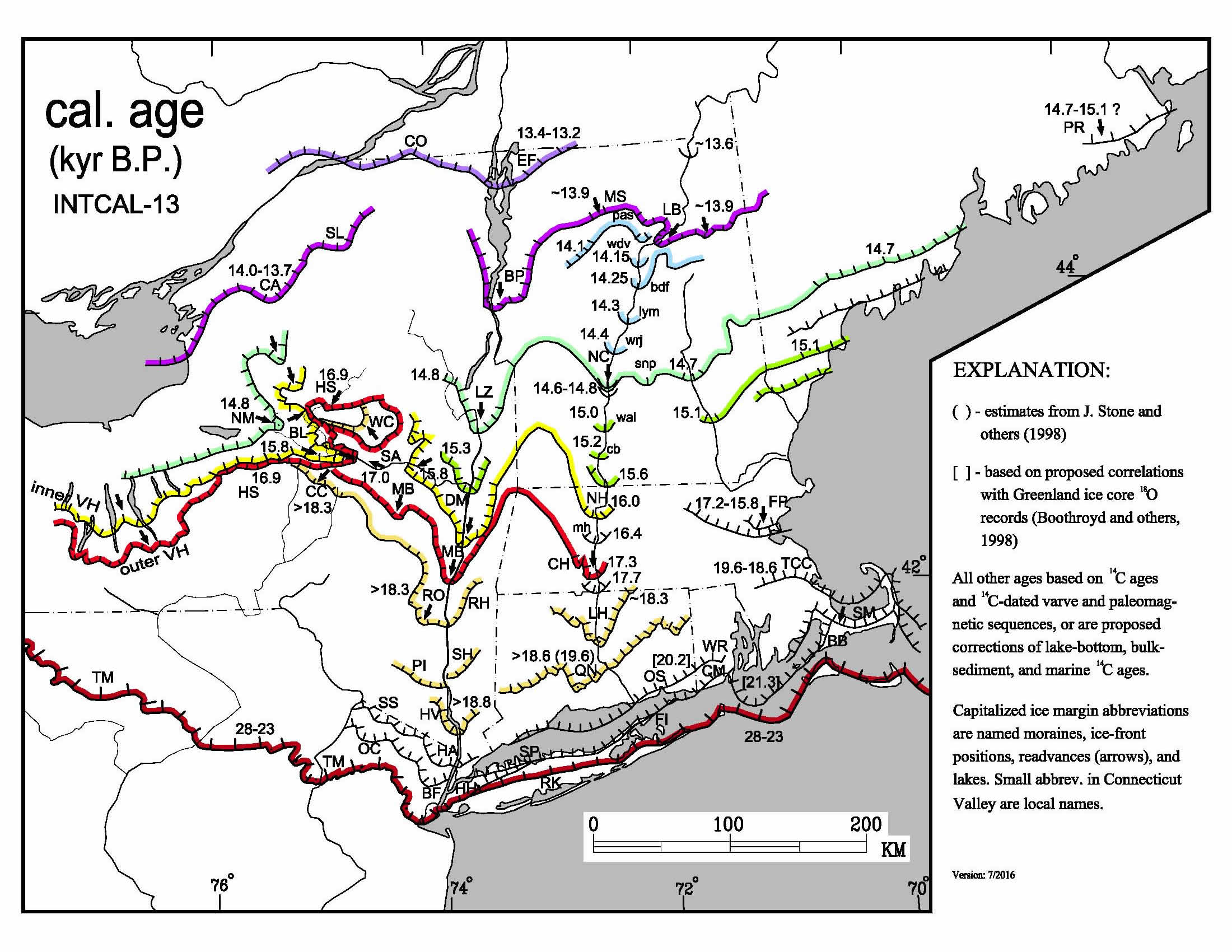
Map of the positions of the front of the Laurentian ice sheet in
eastern New York and New England starting from the maximum extent
23,000 years ago, when the ice front was at the position of Long
Island, to crossing the NY-VT border with Quebec about 13,200 years
ago. Numbers on the map are in 1000's of years before present
(present defined as 1950CE). As the ice retreated north, glacial
lakes grew in the major valleys (see diagram below).
Map and age data compiled on it is an image from and the
product of the North American Glacial Varve Project, Tufts
University.
The glacial lakes of New England and adjacent
New York and Quebec
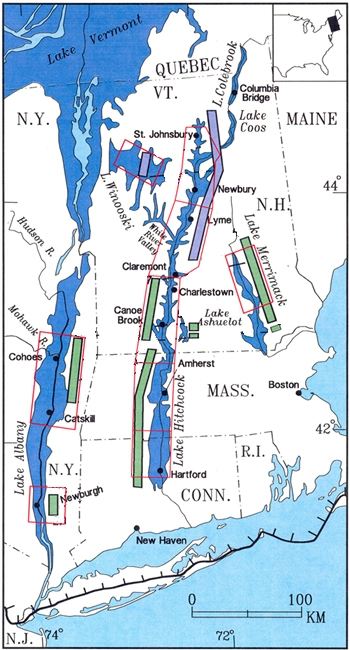
diagram simplified from a map of the New England Varve Chronology (NEVC) Project.
Maximum extents of the large glacial lakes of this region; the lakes
reached the extents shown at different times, so this map is not a
view of the geography of a single time.
Hachured line through Long Island is the former maximum extent of
the Laurentian Ice Sheet (see map above).
Green and violet bars and red boxes are sections where varved clay
layers have been counted, and correlated into an overall time
sequence. See the Varve Project website for all the details.
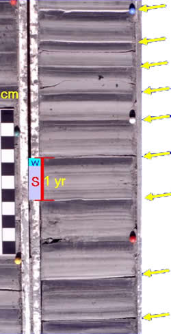
photo of core sample of varved clay and silt
showing the annual alternation from silts (lighter grey) to clay
(darker grey). Yellow arrows point to the base of the silty layers.
One year's deposition of silty material (summer - S in the coloured
bar), and the clay layer (winter - W in the coloured bar).
Black and white bar scale on the left is divided in centimeters
(2.54 cm to an inch).
These varve layers are significantly thicker (particularly the
silt portions) than is typical of varved clay deposits, being from a
location close to the mouth of a former stream entering a glacial
lake. This is chosen to provide a clear illustration of the seasonal
variation and the layers.
Photo from the North American Glacial Varve Project website.
Proto-Great Lakes discharge through the
Mohawk Valley into Lake Albany
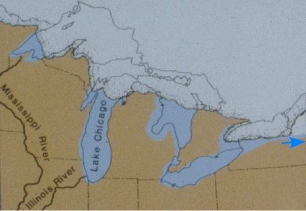
Map reconstruction of the Laurentian ice front and adjacent
developing Great Lakes about 14,500 years ago. At this time,
drainage from the early parts of the future Lakes Huron and Erie
flowed east along the southern margin of the ice lobe occupying the
area of future Lake Ontario and (indicated by the blue arrow) down
the Mohawk Valley into Lake Albany (just off the edge of this map).
This large discharge created the gravel and sand delta of the Mohawk
in Lake Albany, the origin of the Colonie Sand.
Lake Albany shorelines
Lake Albany at the time it was most extensive had shorelines in the
Capital District near present-day elevation of 310 ft above sea
level, and all of the area now McKownville was then 50 feet or more
below the surface of the lake. The lake level fell in several
distinct stages, as the moraine dam at the south end near New York
City began to be overtopped and cut through. One particularly
prominent stage (termed Lake Quaker Springs) has shoreline features
near 250 ft above sea level in this area, of which remnants exist in
the area west of Fuller Road near the McKownville-City of Albany
boundary. Lower temporary shoreline features of Lake Albany at
several levels down to one at 192 ft elevation can also be found in
McKownville; one with a base elevation of about 216 ft forms the
south-facing slopes crossing the middle parts of Glenwood and
Norwood Streets. In McKownville, the local remnants of these lake
shorelines that were cut into the Colonie Sand alternate with very
gently sloping terraces which are the product of smoothing of the
shallow near-shore lake bottom, by waves and perhaps also lake ice
activity, locally redistributing the sand. Small stream channels
formed after the lake levels fell below each shoreline-terrace pair
dissect these landforms in places, and the larger stream channels of
the two branches of the Krum Kill cut locally through all of the
terraces and shorelines below 250 ft elevation. This topographic and
geological profile section, drawn on a line running parallel to and
between Parkwood and Glenwood Streets in McKownville (vertical
scale is enlarged from the natural proportion to make the surface
topographic variations more obvious) shows two of these lake shore
slopes and the terraces below:

Extinct fauna - mastodonts
After the glacial moraine dam near new York City failed and was cut
completely through by the Hudson River, Lake Albany ceased to exist.
The former lake bed became vegetated, and occupied by Native
Americans and the fauna they hunted. Early in this history, and
perhaps from before Lake Albany had fully emptied, large mammals now extinct were present,
including the mastodont. One relatively complete skeleton of this
animal was found in 1866 near Cohoes Falls, during preparations for
construction of one of the Harmony Mills factory buildings; this is
on display in the New York
State Museum in Albany, as is an excellent diorama of a mother
mastodont and her calf, in an appropriately cold, snowy upstate New
York winter landscape:

There is an online exhibition for the Cohoes Mastodon on
the NYS Museum website.
Sand dunes of the Albany Pine Bush
During and after the drainage of Lake Albany, sands of the old
Mohawk River delta were in part redistributed by winds, probably
often strong and very cold, as experienced now in areas near large
continental ice sheets, because of the large temperature gradients
between the elevated glaciated area and the land nearby. Before
vegetation developed and stablised the dunes, migration of sand must
have been significant whenever the wind blew vigorously. Many of the
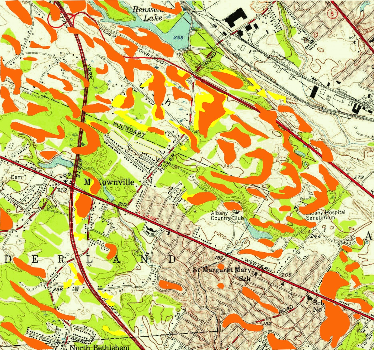
dunes in the Pine Bush near McKownville have long straightish limbs
running WNW-ESE, parallel with the prevailing direction of these
strong winds, and end in hooked and curved downwind terminations, a
form termed "parabolic" dunes. A map below shows the distribution of
these in the area near McKownville, derived from the 1953 USGS
topographic map. This map shows the topography before it was
extensively altered by large construction projects, of the State
University and State Office campuses, the major multilane highways,
shopping malls, etc, which have destroyed many of the dunes since
that map was surveyed and drawn. Prominent dune forms shown by
orange areas; yellow are local extensions to some dunes drawn from
more recent and detailed topographic information. These are just the
topographically prominent features; the wind-transported sand also
blankets a large proportion of the area between the dunes.
The Albany Pine Bush Preserve contains extensive
walking trails in areas where the dunes, and the pine barren
vegetation are intact, to the west of the area shown in the map
above. For walking where dunes are prominent, these trails are
recommended:
the northern part of Karner
Barrens, Blueberry
Hill West, the western part of Truax
Trail Barrens, Kings
Highway Barrens, and Great
Dune.
return to history page


