Flood events and dam breaks in McKownville
The McKownville reservoir outlet and flooding on Western Avenue

Flooding 19 November 1974 on Western Avenue near the Fuller Road
intersection, at the main entrance to the Stuyvesant Plaza
shopping center. This event
was caused by the failure and collapse of the Church Pond dam.
Recurrent flooding of this main
road (US Route 20) occurs because the outlet pipe from the
McKownville Reservoir, running under the main entrance to the
Stuyvesant Plaza shopping center, is undersized for the volume of
runoff discharge directed to it in larger precipitation and snowmelt
events.
Flood events have probably been reduced in
frequency, by the $600K project completed in 2010 in which the
reservoir was drained and converted to a wetland functioning as a
retention pond, with rebuilding of the internal and outlet culverts.
The main sources of this
floodwater come now from run-off from the impervious surfaces
of Crossgates Mall and Commons, and the local parts of the Thruway,
Northway, and Washington Avenue Extension, and lesser amounts from
Stuyvesant Plaza, and from the local sections of Western Avenue and
Fuller Road. To prevent these flooding events more effectively the undersized outlet pipe
from the old McKownville Reservoir that runs below the Stuyvesant
Plaza Western Avenue entrance would have to be replaced. The pipe
was installed before 1960, and was perhaps of adequate size at that
time, when the only significant impervious surfaces supplying runoff
into the Reservoir were the local Thruway section and part of
Stuyvesant Plaza. Addition of the Northway occurred in 1959-60, and
Washington Avenue Extension in 1969, so by the time of the event
shown in the picture above, there was clearly a runoff overload for
high discharge events, including high rainfall or rapid snowmelt.
Addition of the much larger total impervious area of Crossgates in
1983 made things much worse, as they were permitted to create a
detention pond of inadequate size to contain the runoff from larger
precipitation events.
Flood events from dam breakdowns on the Krum Kill
The several ponds along the two branches of the Krumkill
stream were originally all formed by the construction of small earth
and wood dams. These started with ponds on the main west branch of
the Krumkill, dammed by William McKown starting just before 1800, to
supply water to his inn
and tavern and the nearby stables and stockyards. Another dam
was constructed farther upstream, near the McKownville Methodist
Church, perhaps not long after McKown's if it was constructed to
supply the old
tavern and hotel built about 1803, located a short distance
west of the church site. This pond was known as Harrington's ice
pond in the later 19th century, and after, although some called it
Church Pond. The dam for this pond suffered at least two major
breaches which caused flooding downstream, one in 1914, after which
it was rebuilt, and another in
1974, after which it was abandoned, and the former pond became
a wetland, until Crossgates
bulldozed the site in 1983.
The pond now on the University at Albany campus,
formerly the lands of the Albany Country
Club, was created by the Country Club about 1898 or
thereabouts by making an earth and wood dam across the east branch
of the Krumkill stream. The lands of the Club were taken by the State
in January 1961 for construction of the uptown campus of the State
University of New York at Albany.
The dam failed on 21 March 1963, releasing all the pond's contents
of water and some ice into the former channel of the Krumkill
stream.

View southward to Western Avenue down the scoured former channel
and drainpipe for the east branch of the Krumkill stream 21 March
1963.
(image from M E Grenander Special Collections and Archives,
University at Albany)
The drainpipe culvert under Western Avenue understandably was
overwhelmed and the water and mud scoured from the pond and the
stream banks poured over the road, around the houses in the way on
the south side of Western Avenue, sweeping a car off the road and
depositing it some distance downstream, lodged against a tree.
This event happened at the beginning of the spring thaw, and at this
time, in the early stages of construction of the University, it is
probable that nobody was paying attention to the level of the pond.
The photos taken at the dam failure site show
that the pond had been kept filled through the winter, and that the
failure was by undermining and collapse into the rapidly eroded
channel through the dam. The dam was rebuilt, and the pond remains,
but the level in the winter is set and kept low, to avoid a
repetition of this event.

View northward to Western Avenue up the scoured channel of the
east branch of the Krumkill stream 21 March 1963. A car swept down
from Western Avenue is lodged against a tree, right of center.
(image from M E Grenander Special Collections and Archives,
University at Albany)

View southward to Western Avenue from the east side of the
scoured former channel of the east branch of the Krumkill stream
21 March 1963.
(image from M E Grenander Special Collections and Archives,
University at Albany)

View across Western Avenue at the Albany city line showing flood
debris and Kenner's grocery 21 March 1963.
(image from M E Grenander Special Collections and Archives,
University at Albany)

View west along Western Avenue from the Albany city line showing
flood debris cleanup in progress 21 March 1963.
(image from M E Grenander Special Collections and Archives,
University at Albany)
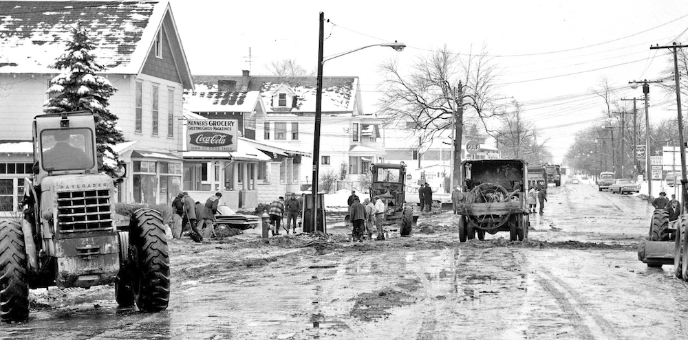
View west along Western Avenue across the Albany city line
showing flood debris cleanup in progress 21 March 1963. Kenner's
grocery on the left.
(image from M E Grenander Special Collections and Archives,
University at Albany)

View east along Western Avenue across the Albany city line with
flood debris in the roadway 21 March 1963. Kenner's grocery on the
right.
(image from M E Grenander Special Collections and Archives,
University at Albany)

View north across the dam and the emptied pond at the site of
failure of the Indian Pond dam 21 March 1963. The country
club boathouse was on the north side of the pond.
(image from M E Grenander Special Collections and Archives,
University at Albany)

View east along the dam and across the eroded channel at the site
of failure of the Indian Pond dam 21 March 1963.
(image from M E Grenander Special Collections and Archives,
University at Albany)

View south from the dam down the eroded channel at the site of
failure of the Indian Pond dam 21 March 1963.
(image from M E Grenander Special Collections and Archives,
University at Albany)
return to McKownville local history
page
McKownville Improvement Association index
page