Historical highway marker for William (Billy)
McKown
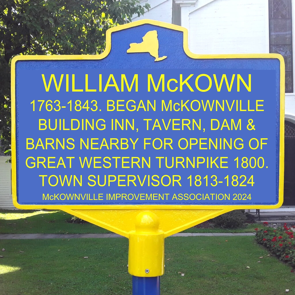
WILLIAM McKOWN
1763-1843. BEGAN McKOWNVILLE
BUILDING INN, TAVERN, DAM &
BARNS NEARBY FOR OPENING OF
GREAT WESTERN TURNPIKE 1800.
TOWN SUPERVISOR 1813-1824
mockup image of William McKown marker sign
This historical marker has been funded by the generosity of local
residents, and the management of Stuyvesant Plaza. Thank you all!
It has been (October 2023) ordered from a business located in New
York State, Catskill
Castings.
We anticipate installing the marker in the spring of 2024,
accompanied by a suitable celebration.
Proposed marker site:
Within property of the Town of Guilderland, part of the McKownville
Reservoir Park, in the grassed area formerly owned by the
McKownville Water District, adjacent to the dam of the former
McKownville Reservoir (first dammed here by William McKown to
provide the main water source for his hotel, tavern, and stockyards)
[location 42.682324, -73.840775] [Google earth kml] *alternative
site
Source documents
a) A map of the Albany and Schenectady Turnpike Road and the
roads in its vicinity
Surveyed in November and December 1805 by John Randel Junr
Map collection of the Albany Institute of History and Art (excerpt
used by permission)
[shows McKown's
T(avern) on the Great Western Turnpike Road, adjacent to
Krumkill stream, unnamed on this map]
b) extract from the story "The Rabid Wolf"
by Henry Rowe Schoolcraft
published in Oneóta; or, Characteristics of the red race of
America, from original notes and manuscripts
Publication date 1845, New York, Wiley & Putnam
[https://archive.org/details/bp_674499]
and in The Indian in his Wigwam, or Characteristics of
the red race of America from original notes and manuscripts
Publication date 1848, Buffalo, Derby & Hewson
[https://archive.org/details/cihm_40630]
The pertinent extract (which refers to a time before Henry
Schoolcraft departed from Albany County in 1809; probably 1807):
"It was late before we got out of the precincts of the city, and up
the hill, and night overtook us away in the pine woods, at Billy
McKown's, a noted public-house seated halfway between the city
and Iosco [Hamilton], where it was customary in those days to halt;
for besides that he was much respected, and one of the most
sensible and influential men in the town, it was not thought
right, what ever the traveller might require, that a horse should be
driven eight miles without drawing breath, and having a pail of
water."
c) William McKown elected Town Supervisor of Guilderland, 1813;
re-elected supervisor each year through 1824.
pages 846-849 in Howell, G.R., & Tenny, J. History of Albany
and Schenectady Counties, Bi-centennial history of Albany. History
of the county of Albany, N. Y., from 1609 to 1886. With portraits,
biographies and illustrations. Publication date 1886, W. W.
Munsell & Co., New York
[https://archive.org/details/cu31924080795127] extract: History
of the Township of Guilderland
Photos of pages from the original Town of Guilderland records book recording
election results for Town officers 1813-1824
The present Town of
Guilderland website does not display any information on former
Supervisors and their tenure.
d) Last will and testament of William McKown [photocopy
image] [text
transcription]
died 1st August 1843; will probated 24 October 1843 (will
dated 25 August 1815)
This contains: "I give and devise to my son John McKown all the land
which I own in the tract called the gore, which was allotted to me
in a partition thereof with the dwelling house, barns, stables,
outhouses & appurtenances thereon which I now occupy", which was
the Hotel and tavern and surrounding land, containing the
stockyards, and ponds dammed along the Krumkill.
e) original gravestone of William McKown [photo
taken by William Donato January 2021]
died August 1st 1843, aged 80 years, 4 months and 15 days; so
born 1763.
The McKown graves and stones were
originally located somewhere behind the McKown Hotel & Tavern;
they were moved to Prospect Hill Cemetery in 1865. New memorial
stones were installed there; the old stones were, it was
discovered in 1973, diverted to make the cellar floor of a
house not far from the cemetery.
f) photo of William McKown's Hotel & Tavern, probably
taken in the winter of 1916-17, owned then by the Witbecks.
It burnt
down one night in early October 1917.
[photo in the files of the Guilderland
Historical Society; also in the W. Mohr archive at the Albany Pine Bush
Preserve].
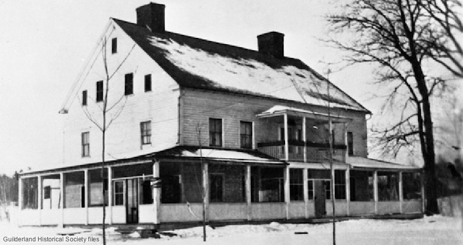
The hotel and tavern was built by William McKown and deliberately
situated to take advantage of the traffic following construction 1799-1804 of the
Great Western Turnpike. He sold the
right-of-way to the Great Western Turnpike Company through his
property, passing directly in front of the hotel, the deed for
this sale by McKown, for 6 cents, dated 1802. At the time he
wrote his will
(1815) he did own the land on both sides of the Turnpike at this
location.
g) clip from
the first USGS 15' map of the Albany quadrangle, published 1893
showing name of McKownville, and indicating the few
houses of the hamlet, including McKown's hotel.
This hotel and tavern was for all of the 19th century the center of
the hamlet of McKownville, and the source of the name was William
McKown (1763-1843) and his family.
h) clip from page 525 of Landmarks of Albany County, Parker,
A.J. (editor), published 1897, D. Mason & Co, Syracuse NY.
brief
description of McKown(s)ville, including source of name
from McKown family.
William McKown's son John McKown (1787-1870) took over the business
when his father died in 1843.
i) clip from the
Map of Albany County by J. Sidney, published 1851.
Shows J(ohn) McKowns Hotel, and names other houses nearby.
John McKown's son James F McKown (1818-1880) became the first
postmaster in 1862, and the hotel accommodated the McKownville post
office until 1905.
j) page
including image of 1871 Post Office document requesting
information for McKownville PO, and a list of postmasters.
We have been unable to find any contemporary primary source document
for the claim that William McKown built his hotel and tavern before
the Great Western Turnpike was built (the eastern section was opened
in 1800), or even legally
authorized (1799), although all the secondary-type sources we
have seen agree that this was so. The earliest source we have is the
Altamont
Enterprise report of the destruction of the (Witbeck's,
formerly McKown's) hotel by fire in 1917. This article states that
it was built in 1793. That date was also given by Benjamin
Witbeck in an interview
in 1940 with William Efner, the Schenectady historian. It is
repeated in most articles after that date, except for the bicentennial
drive-it-yourself historical tour guide of Guilderland,
published in 1976, which gives a building date of 1796. This
guide was compiled by members of the Guilderland Historical Society
and published by that organization. Fred Abele was the president of
the Society at that time, and a subsequent unpublished manuscript he
wrote about 1982 on the history of McKownville repeats that 1796
building date.
It seems to us unlikely that William McKown would build a, for the
time, large hotel and tavern a mile off in the pine woods on a
"road" to nowhere, and leave it empty, or use it only for a family
home, for seven years, while still leasing, and operating the Five Mile House tavern
on the King's Highway. Three years, and including construction of
outbuildings, and stockyards, and the water system and new dam on
the Krumkill, seems somewhat more plausible. So we think that c.1796
is a more reasonable estimate for the start of construction. It
seems unlikely that any primary, contemporary document will be found
to resolve this uncertainty, but three separate deeds whereby William McKown obtained
ownership of the gore property where the hotel was built are
dated in April 1797, December 1798, and December 1800. Possibly he
leased the property before concluding all the purchase agreements.
Evidence that there were extensive stock pens and yards associated
with McKown's hotel is given in a 1928 Knickerbocker
Press article, and on a map of the
hotel site and surroundings made in 1940 by William Efner.
William McKown's will dated 1815 mentions the "barns, stables,
outhouses, and appurtenances thereon".
* An alternative marker site was considered: 1470
Western Avenue; front grass area of the Burger King restaurant
(which is part of the former site of McKown's Hotel and Tavern)
[location 42.681352, -73.838932] [Google Earth kml].
The property owner indicated that obtaining consent from Carrolls,
the chain owner, would undoubtedly be difficult.
The marker as originally proposed contained this text; modified
after discussion among members of the board of the McKownville
Improvement Association to that finalised and shown at the top of this web page:

WILLIAM McKOWN
1763-1843
FOUNDER OF McKOWNVILLE
TOWN SUPERVISOR 1813-1824
BUILT HOTEL, TAVERN AND
STOCKYARDS NEARBY c.1796
return to McKownville Improvement
Association index page
