McKownville old water systems - William McKown's wooden pipes
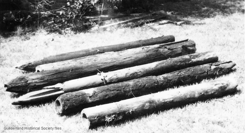
Water piping made of bored-out pine trunk segments, unearthed near
the former McKownville filtration plant during excavations in 1966.
These are the relics of the water supply system installed by William
McKown for his hotel and stables, and livestock yards, in the late
1790's to early 1800's.
Reported in Altamont
Enterprise article 8 August 1969.
Photo from Guilderland Historical society files.
William McKown (1763-1843), who built the McKown Hotel and Tavern,
also constructed an extensive water supply for the building and for
the livestock and horses that arrived there. He built several dams
across the main west branch of the Krumkill (on old maps, Kromme
Kill) stream which passed near the west side of and behind the
hotel. The main supply pond was located on the north side of the
Western Turnpike where the McKownville reservoir and the former
McKownville water filtration building are still found today. In
order to bring water under the Great Western Turnpike to the hotel
and stockyard on the south side, William McKown used a network of
wooden pipes, made from pine tree trunks bored out and the ends
shaped to fit one piece to the next. Articles
published in the Turnpike Record by Fred Abele in 1969 give
some historical background and describe how a number of these pipes
were unearthed in 1966 in excavations made near the old filtration
building and were given to the Altamont Farm Museum for preservation
and display.
Another branch of William McKown's wooden water pipe system was encountered
in 1932 during the excavation for the basement of the house
being then constructed at 9 Elmwood Street. In that case, the house
builder took an axe to what he first thought was a large tree root,
and was considerably surprised when a good flow of cold water
started running from this into his new excavation. It only stopped
when he cut the old wooden pipe cleanly and hammered a
burlap-wrapped tapered pine plug into the end. The source of the
water, and the further extent of this pipe, were not traced, nor was
any more of the old pipe removed than necessary to install the
basement walls, so its remains should still be there in the ground,
behind this house. It seems possible that this pipe was installed
along the route of the track that McKown is known to have cleared to
connect his new hotel and tavern with the old "Five Mile House"
hostelry he had been leasing since 1786 on the old King's Highway
between Albany and Schenectady, located about 3/4 mile to the east,
near the eastern branch of the Krumkill. A track with this direction
is shown on the Sidney map of 1851, and
on the Randel
map of 1805.
Some old maps and reports tell of "a great overflowing spring" on
the north side of the Turnpike west of Fuller Road. It is not clear
if this just means the flow of the Krumkill, or whether there was a
separate source of water in a natural spring in the bank of the
stream here. The high water table in the shallow unconfined sand
aquifer which extends over almost all of McKownville allows the
possibility that there was such a separate spring, and that McKown
also used this supply. In the 1940's and earlier 1950's, the land
next to the reservoir ponds was not built over by the Stuyvesant
Plaza shopping center, being described by William J Embler as "a
tangle of brush, and rather marshy. Our sons trapped muskrats
there."
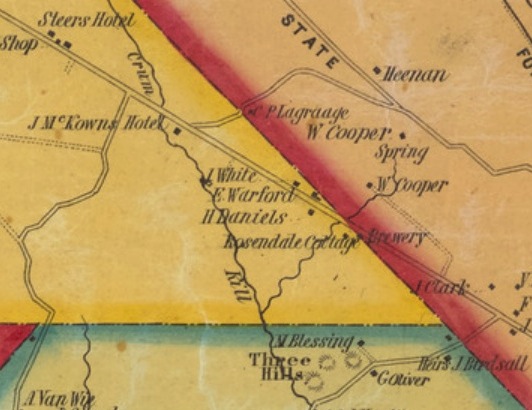
McKownville area on the 1851 Sidney Map
of the vicinity of Albany and Troy, showing the location of
McKown's Hotel on the south side of the Great Western Turnpike near
the main west branch of the Crum Kill, the hotel at this date
inherited by William McKown's son John A McKown. The track heading
northeast from the hotel, passing Christian P LaGrange's farmhouse,
is likely to be the one made by William McKown to connect his (in
1793 new) hotel with the old tavern he leased on the King's Highway
(the road labelled State), perhaps the northern of the two
structures labelled W Cooper on this map, near the spring marked at
the head of the east branch of the Crum Kill stream.
return to McKownville older
buildings photo index page
return to McKownville Improvement
Association index page